The documentary evidence behind three official narratives, with the accessibility of each original noted. One point belongs at the top rather than inside a card: Japan's position is that no territorial dispute exists here at all, so the three-narrative form of this page is itself something Japan rejects. That is a fact about the dispute, recorded here, not a judgement on it. Every card in the three narratives carries the other parties' rebuttals — or, where two parties argue the same way, a statement of how their cases diverge. Third-party cards state their own limits instead. This document endorses no claim.
VOTEWhich story do you find more convincing?↓Naming rule There is no neutral cartographic settlement here, and any single headline name is itself a position. The Congressional Research Service — the US Congress's own reference service — titles its report with all three names, and this edition follows that practice · The order of the three narrative sections below is randomized on every visit
Japan leads onChina leads onTaiwan leads onread in opposite ways
Current status — as of August 2026 Status as of 2026-08
De facto control 🇯🇵 Japan, continuously since the reversion of Okinawa on 15 May 19722026-08
Population uninhabited since the collapse of the Koga business around 19402026-08
Area the three governments do not agree. Uotsuri / Diaoyu Dao / Diaoyutai is registered by Ishigaki at 3.82 km², given as 3.91 km² by the PRC white paper and as 4.5 km² by ROC MOFA; group totals run about 7 km² (Japan), 5.69 km² (PRC) and 6.5 km² (ROC)2026-08
Japan / Ishigaki3.82 km²
PRC white paper3.91 km²
ROC MOFA4.5 km²
Last settlement peaked at 248 residents in 99 households in 1908, under a lease granted in 18961908
Japan's administrative designation Ishigaki City, Okinawa Prefecture, covering Uotsuri (Diaoyu Dao / Diaoyutai), Kuba (Huangwei Yu) and Taishō (Chiwei Yu) among others. The city council voted in June 2020 to rename the administrative district from 登野城 to 登野城尖閣, effective 1 October 2020. Both Beijing and Taipei protested; Taiwan's foreign ministry called the change "invalid"2020-10
China's designation affiliated to Taiwan Island. Standard names were announced in March 2012, and territorial-sea baselines were declared on 10 September 2012 and deposited with the UN Secretary-General on 13 September2012-09
Taiwan's designation Daxi Village, Toucheng Township, Yilan County. The PRC describes the islands as affiliated to Taiwan Island; the two have issued no joint designation2026-08
Ownership Uotsuri (Diaoyu Dao), Kitakojima (Bei Xiaodao) and Minamikojima (Nan Xiaodao) were transferred from the Kurihara family to the Japanese state on 11 September 2012 for ¥2.05 billion. Kuba remains privately owned and Japan levies tax on it — cited by its foreign ministry as evidence of valid control; Taishō is state land. Both Kuba and Taishō have been offered to United States forces as facilities since 1972 and were used as live-fire ranges from the 1950s. Japan's foreign ministry characterises the transfer as "nothing more than returning the ownership from a private citizen to the Government, with which the ownership rested until 1932"2012-09
Japan's position"There exists no issue of territorial sovereignty to be resolved concerning the Senkaku Islands" — which is why Japan neither negotiates nor arbitrates over them2026-08
China's position the islands are Chinese territory taken during the 1894–95 war, and the American transfer of administrative rights to Japan in 1972 was 完全是非法的 — wholly illegal2026-08
Taiwan's position the islands were Qing territory and not terra nullius in 1895, and were ceded with Taiwan under the Treaty of Shimonoseki. Taipei's 1996 four principles rule out resolving the matter jointly with Beijing2026-08
United States position the mutual security treaty covers territories under Japanese administration, and Article V has been reaffirmed as applying here — most recently in the Trump–Ishiba Joint Leaders' Statement of 7 February 2025 — while the United States maintains that it takes no position on the underlying sovereignty. No 2026 restatement was located2025-02
Japanese patrol presence the 11th Regional Coast Guard Headquarters at Naha, with a dedicated territorial-waters patrol unit stood up at Ishigaki in 20162026-08
Chinese Coast Guard presence, July 2026 vessels in the contiguous zone on 28 of 31 days, 114 vessel-days cumulative; territorial-sea entries on 2 days, 6 vessels. The standing presence is almost invariably 4 vessels2026-07
Chinese Coast Guard presence, August 2026 contiguous zone on 22 of the first 23 days, 86 vessel-days; a territorial-sea entry on one day, 14 August, 4 vessels2026-08-23
⚠ Three cautions about this page. The patrol figures move every month — they are taken from the Japan Coast Guard's own daily counts, which is the only continuous published series, and are stamped accordingly; they measure Chinese activity as recorded by one of the parties. The naming is itself contested: Japan objects to dual naming as implying a dispute exists, while China and Taiwan object to "Senkaku"; no arrangement of the three names is neutral to everyone, including the one at the top of this page. And this dispute has three parties, not two — Taipei has formally refused to handle it jointly with Beijing, so the common shorthand "China and Taiwan" describes an alignment neither government has agreed to.2026-08
Change log
Four Chinese Coast Guard vessels entered the territorial sea — the single such entry recorded in the first 23 days of August.
Japan's education ministry approves textbooks describing the islands as Japanese territory; the Chinese foreign ministry protests: 钓鱼岛及其附属岛屿自古就是中国的固有领土 — whatever Japan does in its textbooks cannot change the fact that Diaoyu Dao belongs to China.
Ambassador Wu Jianghao protests over a Japanese civilian aircraft, with Beijing stating it took necessary control measures to warn and expel it — an assertion of air jurisdiction, not only maritime.
China's Coast Guard Law enters into force. Japan's foreign ministry calls its provisions problematic, including the authorization for the use of weapons.
Ishigaki City's renaming of the administrative district from Tonoshiro to Tonoshiro Senkaku takes effect. Beijing and Taipei both protested; Taiwan's foreign ministry called the change invalid.
Taiwan and Japan sign a fisheries agreement adding roughly 4,530 km² of protected operating area for Taiwanese fishermen, bracketing the sovereignty question. Beijing has concluded no equivalent arrangement.
Japan registers the transfer of three islands from private ownership to the state for ¥2.05 billion. Tokyo framed the purchase as pre-empting a more provocative plan by Governor Ishihara, announced 18 April; Beijing called it a gross violation of Chinese sovereignty, and protests followed in as many as 85 Chinese cities.
China declares territorial-sea baselines around the islands, the day before the Japanese purchase is registered; they are deposited with the UN Secretary-General on 13 September.
President Ma Ying-jeou announces the East China Sea Peace Initiative: safeguard sovereignty, shelve controversies, pursue peace and reciprocity, promote joint exploration and development.
The Republic of China states its formal claim to the islands, six months before the PRC's statement of 30 December.
Administrative rights transfer to Japan with the reversion of Okinawa. The United States states that the transfer cannot prejudice any underlying claims.
⇄ The order of the three narrative sections below is randomized on every visit.
Japan's narrative 6 sources
Ten years of survey finding no trace of Qing control, a formal act of state three months before the Treaty of Shimonoseki, four decades of licensed and taxed settlement, a Chinese consul's letter placing the islands in Okinawa Prefecture, and seventy-five years in which, on Japan's reading, no one objected.
MOFA, "The Basic View on the Sovereignty over the Senkaku Islands" first issued 8 March 1972; last updated 8 May 2013
The load-bearing document of the Japanese case. It rests on occupation of terra nullius: ten years of survey from 1885 to 1895, a finding of no Qing control, then a formal act of state. Japan also denies that a dispute exists at all — a position that shapes everything downstream, including its refusal to negotiate or arbitrate.
Historically, the Senkaku Islands have continuously been an integral part of the Nansei Shoto Islands, which are the territory of Japan. From 1885 on, surveys of the Senkaku Islands were thoroughly carried out by the Government of Japan through the agencies of Okinawa Prefecture and by way of other methods. Through these surveys, it was confirmed that the Senkaku Islands had been uninhabited and showed no trace of having been under the control of the Qing Dynasty of China. Based on this confirmation, the Government of Japan made a Cabinet Decision on 14 January 1895 to erect a marker on the Islands to formally incorporate the Senkaku Islands into the territory of Japan. — and: "There exists no issue of territorial sovereignty to be resolved concerning the Senkaku Islands."
Meaning
Japan's argument is that if the islands were ownerless in 1895, the Shimonoseki cession is irrelevant, the Cairo and Potsdam restitution logic has nothing to attach to, and the Chinese historical records become records of knowledge rather than of title.
China rebuts
The 2012 white paper answers head-on: "Diaoyu Dao belongs to China. It is by no means 'terra nullius'. China is the indisputable owner of Diaoyu Dao as it had exercised valid jurisdiction over the island for several hundred years long before the Japanese people 'discovered' it."
Taiwan rebuts
ROC MOFA's answer to the incorporation itself: "As the Japanese cabinet did not make public the resolution it passed regarding the islands, the decision was never legally binding on the Qing dynasty and later the Republic of China (Taiwan)." On Taipei's reading the islands were Qing territory and not terra nullius, so what 1895 effected was not occupation but a taking.
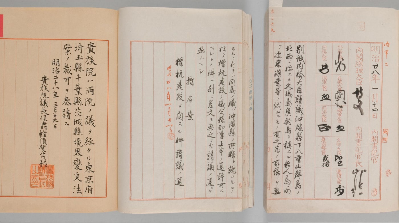
The Cabinet Decision of 14 January 1895 明治28年1月14日閣議決定
Home Minister Nomura Yasushi's submission of 12 January 1895 responded to petitions from the Governor of Okinawa dated 22 September 1885 and 2 November 1893. The original, bearing the signatures of Prime Minister Itō Hirobumi and Nomura, is held by the National Archives of Japan. It was not published — Japan concedes this.
同島ノ儀ハ沖縄県ノ所轄ト認ムルヲ以テ標杭建設ノ儀同県知事上申ノ通許可スヘシ — "As the said islands are recognized to be under the jurisdiction of Okinawa Prefecture, the erection of markers shall be permitted as petitioned by the prefectural governor."
Meaning
Japan's formal act of appropriation, and — Japan stresses — dated three months before the Treaty of Shimonoseki of 17 April 1895, and therefore legally severable from it.
China rebuts
The white paper: "The Japanese cabinet secretly passed a resolution on January 14 to 'place' Diaoyu Dao under the jurisdiction of Okinawa Prefecture … Japan had consistently acted in secrecy without making its moves public. This further proves that Japan's claim of sovereignty over Diaoyu Dao does not have legal effect under international law." China adds the timing: the decision was taken while the First Sino-Japanese War was being fought, after the fall of Lushun, and so cannot be treated as an ordinary peacetime acquisition severable from the war and the cession that followed.
Taiwan rebuts
ROC MOFA's objection is procedural and its own: the resolution was "not officially made public through the normal procedure of an imperial decree," and because the cabinet did not publish it, "the decision was never legally binding on the Qing dynasty and later the Republic of China (Taiwan)."
original publisheddocumentedJapan's answer on secrecy, MOFA Q11: "It is true that the Cabinet Decision of 1895 was not made public, but it is understood that so were Cabinet decisions in general at that time… Under international law, there is no obligation to notify other countries of a government intention to occupy terra nullius"Ishigaki City Senkaku Digital ArchiveCabinet Secretariat
Koga Tatsushirō's lease and settlement 1896 – c. 1940
Koga Tatsushirō, a marine-products merchant from Fukuoka, received free-use rights over four state-owned islands and from March 1897 dispatched workers — albatross feathers first, then dried bonito. By 1908 the settlement reached 248 residents in 99 households, and Japan levied taxes on them. The business failed around 1940 and the islands have been uninhabited since. In the 1970s Koga's son sold four islets to the Kurihara family, the chain of title that ends when the Japanese state bought them in 2012, in what Japan calls nationalization.
A resident of Okinawa Prefecture who had been engaging in activities such as fishery around the Senkaku Islands since around 1884 made an application for the lease of the islands, and approval was granted by the Meiji Government in 1896. After this approval, he sent workers to those islands and ran the following businesses: collecting bird feathers, manufacturing dried bonito, collecting coral, raising cattle, manufacturing canned goods and collecting mineral phosphate guano. — MOFA Q&A
Meaning
Japan's effectivités evidence: not a paper claim but decades of visible, licensed and taxed economic occupation — the continuous and peaceful display of state authority that international tribunals weigh.
Taiwan rebuts
ROC MOFA gives the sharpest version: the islands were part of Japanese-held territory throughout the Japanese occupation of Taiwan, so Japanese administration during those years proves only that Japan held what it had taken in 1895 — it cannot prove the taking was lawful, and it cannot run as prescription against a sovereign that had been dispossessed by the same act.
China rebuts
Beijing's 2012 white paper does not address the Koga settlement at all; China's answer is structural — the underlying 1895 title was void ab initio, so nothing built on it can ripen into sovereignty. The doctrinal form of the argument is that Japanese control was interrupted between 1945 and 1972, and that possession since 1972 is derived from the American transfer rather than self-generated, so the continuous display of authority that effectivités requires is broken where it would matter most.
original publisheddocumentedBeijing's 2012 white paper does not engage the Koga settlement at allMOFA — the Koga settlement
Letter of thanks from the ROC Consul at Nagasaki 20 May 1920
Thirty-one Fujianese fishermen drifted onto Uotsuri on 30 December 1919 and were rescued by workers at the Koga bonito plant. Seven letters were issued in May 1920 to village officials and rescuers; two originals survive, held at the Ishigaki City Yaeyama Museum.
中華民國八年冬福建省惠安縣漁民郭合順等三十一人遭風遇難飄泊至日本帝國沖繩縣八重山郡尖閣列島內和洋島 — "In the winter of the 8th year (1919) of the Republic of China, 31 fishermen from Hui'an County, Fujian Province were lost due to the stormy wind and were washed ashore on the Wayo Island, of the Senkaku Islands, Yaeyama District, Okinawa Prefecture, Empire of Japan…"
Meaning
Japan's strongest single piece of Chinese-issued evidence: an accredited ROC diplomat, in a formal instrument, locating the islands inside the Empire of Japan, Okinawa Prefecture. Japan reads it as recognition.
China and Taiwan rebut
Three lines of answer, common to both. A consular thank-you note is not an act of state and cannot cede territory, since consuls have no treaty-making capacity. The year 1920 falls squarely inside the period when Taiwan itself was a Japanese colony, so the consul was describing the administrative reality he was obliged to describe, not conceding title. And the character string 和洋島 is philologically contested.
San Francisco Peace Treaty, Articles 2(b) and 3 1951 · 1971–72
Neither article names the islands. Japan's bridge is USCAR Civil Administration Proclamation No. 27 of 25 December 1953, whose coordinate box encloses them, and the same coordinates reproduced in the Agreed Minutes to the 1971 Okinawa Reversion Agreement, which returned administrative rights on 15 May 1972. Japan adds Dulles's statement at San Francisco that the United States permitted Japan to retain residual sovereignty over these islands.
Art. 2(b): "Japan renounces all right, title and claim to Formosa and the Pescadores." · Art. 3: "…the United States will have the right to exercise all and any powers of administration, legislation and jurisdiction over the territory and inhabitants of these islands, including their territorial waters" — Nansei Shoto south of 29° north latitude.
Meaning
Japan's postwar title chain: the islands were never renounced, were administered by the United States as part of the Nansei Shotō, and came back with Okinawa.
China rebuts
China was excluded from the conference and rejected the result before it was signed: Zhou Enlai declared on 15 August 1951 that any such treaty would be "regarded as illegal and therefore invalid," and again on 18 September 1951. Its objection to the bridge is separate — USCAR Proclamation 27 "arbitrarily expand[ed] its jurisdiction to include China's Diaoyu Dao" — and the scholarly version of it is that a post-hoc unilateral American declaration does not carry the weight of a treaty provision, that "Nansei Shotō" in its geographic sense excludes these islands, and that the islands were never discussed in preparing the peace treaty at all.
Taiwan rebuts
Taipei's objection is that it was shut out of the instrument: ROC MOFA records that the Republic of China "was not invited to take part in the San Francisco Peace Conference of 1951." It adds that between 1945 and 1971 the islands were under American administration rather than Japanese, so "the ROC had no basis on which to lodge a protest with the Japanese government at that time."
The People's Daily article of 8 January 1953 琉球群島人民反對美國佔領的鬥爭
Japan cites this more heavily than any other Chinese-origin item, in three separate Q&A answers. It is paired with a 1958 atlas from a Chinese map publisher that labels them the Senkaku Group and places them with Okinawa, and with the absence of Chinese protest while the United States used Kuba and Taishō as live-fire ranges from the 1950s. On the atlas, Beijing's printed note says its borders were drawn from a pre-liberation Shen Bao atlas; MOFA replies that the same atlas already labels Taiwan as PRC territory, so retaining a colonial-era label only here is "unnatural."
The Ryukyu Islands lie scattered on the sea between the Northeast of Taiwan of our State and the Southwest of Kyushu, Japan. They consist of 7 groups of islands; the Senkaku Islands, the Sakishima Islands, the Daito Islands, the Okinawa Islands, the Oshima Islands, the Tokara Islands and the Osumi Islands. — MOFA provisional translation
Meaning
Japan's acquiescence and estoppel case: the Chinese Communist Party's own organ, in the middle of a polemic against the American occupation of the Ryukyus, put the islands inside the Ryukyus and used the Japanese name for them. MOFA: "China has not explained at all why it did not object." The answer both other parties give to the wider seventy-five-year silence is that they were in no position to break it — Taiwan was itself under Japanese colonial rule for fifty of those years, and the PRC was diplomatically isolated for most of the rest.
China rebuts
The answer here is scholarly rather than official. The historian Liu Jiangyong argues the piece was an unsigned reference item — neither editorial nor commentary — and so not a statement of government position; Jin Canrong argues its thesis was Ryukyuan independence rather than Japanese title; and the PRC had already declared the whole San Francisco framework void in 1951, which on its account made itemized protest pointless. Beijing's 2012 white paper does not address the article at all.
Taiwan's position
The research behind this page records no ROC position on the 1953 article. In January 1953 the Republic of China government was in Taipei and the newspaper was the organ of the party it had just lost a civil war to; nothing is attributed to Taipei here.
original publisheddocumentedThe Japanese scholar Arasaki notes the article also lists the Ōsumi Islands among the Ryukyus, which cuts against treating it as authoritative on geography either wayIshigaki City Senkaku Digital ArchiveMOFA — Q&A (A5, A13)
China's narrative 6 sources
Five centuries of Chinese navigational and coastal-defence records naming the islands, a boundary the envoy texts place east of them, a Japanese cartographer who coloured them as China, and Japan's own archives showing a government that surveyed in secret for nine years and moved only after Lushun fell.
Shunfeng Xiangsong 順風相送 attributed to 1403
China's own foreign ministry states the provenance plainly: the surviving copy, held at the Bodleian Library in Oxford, is a transcribed manuscript of the Wanli era — that is, 1573–1620, not 1403. The 1403 attribution rests on the argument that Yongle-era officials repeatedly corrected transcriptions of an older text. The document is a compass-route manual, not an administrative record.
The earliest historical record of the names of Diaoyu Dao, Chiwei Yu and other places can be found in the book Voyage with a Tail Wind published in 1403… It shows that China had already discovered and named Diaoyu Dao by the 14th and 15th centuries. — 2012 white paper
Meaning
China's argument is priority of discovery and naming — the foundation stone of the case that the islands were not terra nullius in 1895.
Japan rebuts
MOFA: "Under international law, for example, the discovery of an island or geographical proximity alone does not evidence the assertion of territorial sovereignty." And on the corpus as a whole: "the contents of these documents are completely insufficient as evidence to support China's assertion when those original documents are examined."
Taiwan's position
Taipei does not dispute the Chinese documentary record — it relies on much of it. Its divergence is over what follows: ROC MOFA argues the question is one of occupation and prescription rather than of discovery, and that the operative fact is the islands' status as Qing territory in 1895, not their appearance in a fifteenth-century route manual.
copies publisheddocumentedThe surviving manuscript is a Wanli-era transcription; this is stated by China's own foreign ministry, not only by its criticsPRC MFA — Diaoyu Dao documentsGlobal Times
Chen Kan, Shi Liuqiu Lu 使琉球錄, and Guo Rulin 1534 · 1561–62
Between 1372 and 1866 the Ming and Qing courts sent 24 title-conferring missions to Ryukyu, and the islands lay on the route. The white paper stacks a corroborating chain: Xie Jie in 1579, Xia Ziyang in 1606, Wang Ji in 1683 describing the 黑水溝 beyond Chi Yu as the 「中外之界」 — the boundary between China and foreign land — Xu Baoguang in 1719, Zhou Huang in 1756. It also cites Ryukyuan sources, including the Annals of Chūzan of 1650, drafted under Ryukyu's own prime minister.
過釣魚嶼,過黃毛嶼,過赤嶼…十一日夕,見古米山,乃屬琉球者。 — "…passed Diaoyu Yu, passed Huangmao Yu, passed Chi Yu… On the evening of the 11th, Gumi Mountain came into sight, which belongs to Ryukyu." · Guo Rulin, 1561: 「赤嶼者,界琉球地方山也」 — "Chi Yu is the mountain that marks the boundary of Ryukyu."
Meaning
China's boundary argument: if Kume is where Ryukyu begins, and the Okinawa Trough is the divide, then everything west of it — including these islands — lay on the Chinese side of a frontier both courts recognised.
Japan rebuts
MOFA: "although these documents showed that Kume Island belonged to Ryukyu, they did not have any reference that the Senkaku Islands, located to the west of Kume Island, belonged to the Ming or Qing Dynasty of China." Japan's reading is that a text fixing where foreign territory begins does not thereby fix where Chinese territory ends.
Taiwan's position
Taipei cites the same envoy texts, but its case does not stand or fall with them: ROC MOFA's argument runs through Qing administrative attachment to Taiwan and then through Article 2 of the Treaty of Shimonoseki, so the envoy record functions as corroboration of pre-1895 status rather than as the operative title.
The claim escalates from knowledge to jurisdiction. The white paper chains it forward through the Qian Kun Yi Tong Hai Fang Quan Tu of 1605 and Mao Yuanyi's Wubei Zhi of 1621 into the Qing, where it says the islands were placed under the jurisdiction of the local government of Taiwan, citing the Tai Hai Shi Cha Lu of 1722 and Vol. 86 of the Recompiled General Annals of Fujian of 1871, which placed them under Gamalan, Taiwan — today's Yilan County.
In 1561 … An Illustrated Compendium on Maritime Security compiled by Zheng Ruozeng under the auspices of Hu Zongxian, the supreme commander of the southeast coastal defense of the Ming court, included the Diaoyu Dao Islands on the "Map of Coastal Mountains and Sands" and incorporated them into the jurisdiction of the coastal defense of the Ming court. — 2012 white paper
Meaning
China's bridge from documentary knowledge to administrative attachment, and the indispensable step: without the islands being an appurtenance of Taiwan, the Shimonoseki and Cairo–Potsdam arguments have nothing to attach to. It is also the direct source of Taipei's Yilan County designation.
Japan rebuts
MOFA A6: "The book, however, is not clear regarding whether these groups of islands were within the coastal defense of the Ming Court. The mere fact that the Senkaku Islands were printed on that map does not mean that they were generally regarded as territory of China at that time."
Taiwan's position
Taipei relies on the same Qing attachment to Taiwan but assigns the islands differently: the ROC places them in Daxi Village, Toucheng Township, Yilan County, whereas the PRC describes them as affiliated to Taiwan Island. The two governments have issued no joint designation.
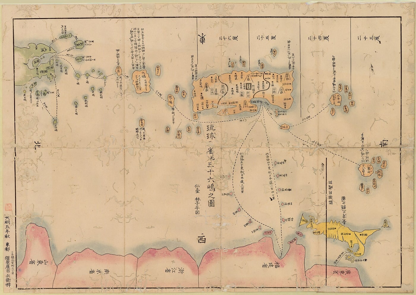
The map is colour-coded by polity. China's argument is that a Japanese cartographer, unprompted, placed the islands outside Ryukyu and inside China's colour field, annotating them with the characters 釣魚臺. The white paper reinforces this with Western maps: Lapie's of 1809, a British map of 1811, Colton's of 1859, and a British Admiralty chart of 1877.
The book Illustrated Outline of the Three Countries written by Hayashi Shihei in 1785 was the earliest Japanese literature to mention Diaoyu Dao. The Map of the Three Provinces and 36 Islands of Ryukyu in the book put Diaoyu Dao as being apart from the 36 islands of Ryukyu and colored it the same as the mainland of China. — 2012 white paper
Meaning
China's most quotable item: an admission against interest, drawn from the other side's own literature.
Japan rebuts
MOFA A7: the map "does not evidence accurate knowledge as shown by the fact, for instance, the size of Taiwan in the map is only about one-third of that of Okinawa's main island." Japanese commentators add that the palette is not binary on close inspection — the islands appear in a peach tone and Taiwan in yellow — and that Hayashi was a private scholar whom the Tokugawa shogunate punished, confiscating his printing blocks for his geographical writings, so the map carries no state authority. The Taiwan-size point can be checked against the image linked on this card.
Taiwan's position
Taipei cites the same map. Its argument does not depend on it: ROC MOFA rests on the legal characterisation of 1895 — occupation and prescription against territory that was not terra nullius — for which an eighteenth-century private map is corroboration rather than proof.
Japan's own internal record, 1885–1894 21 Oct 1885 · 12 May 1894 · 27 Dec 1894
The white paper builds a nine-year timeline entirely out of Japanese archival material compiled by Japan's own foreign ministry. Inoue also advised that it would be inappropriate to publicize the missions in the official gazette or newspapers. Nomura's note of 27 December 1894 followed the fall of Lushun.
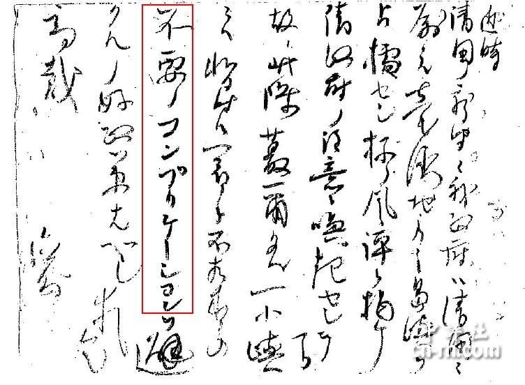
At present, any open moves such as placing sovereignty markers are bound to alert the Qing imperial court. Therefore, it is advisable not to go beyond field surveys… In the meantime, we will wait for a better time. — Inoue Kaoru to Yamagata Aritomo, 21 October 1885 · "there exist no old records related to the said island or folklore and legends demonstrating that the island belongs to our country" — Okinawa Prefecture's secret survey conclusion, 12 May 1894 · "circumstances have now changed" — Home Minister Nomura to Foreign Minister Mutsu, 27 December 1894
Meaning
China's argument is that Japan's own files show a government that knew the islands were not free to take, concealed its surveys for nine years, recorded in May 1894 that it had no evidence of Japanese title, and acted only once the war had turned.
Japan rebuts
MOFA's reading of the same letter is that Japan worried about arousing Qing suspicion, not about Qing title: "It is impossible to interpret it as the acknowledgement by the Government of Japan that the Qing Dynasty held the Senkaku Islands as its territory. Rather, the document shows how Japan proceeded with the process of incorporation carefully and cautiously on the premise that the Senkakus did not belong to Qing Dynasty." Japan deploys a second letter from the same month and file as its own counter-evidence — Yamagata's of 9 October 1885, recording that the islands "were mentioned as a mere direction in the course of voyage and showed no particular trace of having been under the control of the Qing Dynasty while the islands' names were different between them and us."
Taiwan's position
Taipei uses the same archive to a narrower end. Its case does not require proving that Japan believed the islands were Chinese, only that they were not ownerless — so the May 1894 finding that Japan had no records of its own title, and the timing of the January 1895 decision, are cited as evidence about the character of the acquisition rather than about Japanese belief.
PRC Foreign Ministry statement, and the 1992 Territorial Sea Law 30 December 1971 · 25 February 1992
Issued in response to ratification of the Okinawa Reversion Agreement, this is Beijing's first comprehensive formal claim, and every subsequent PRC statement descends from it. It was codified in the Law on the Territorial Sea and the Contiguous Zone of 25 February 1992, which names "Taiwan and the various affiliated islands including Diaoyu Dao"; then the Law on the Protection of Offshore Islands in 2009, standard names announced in March 2012, and territorial-sea baselines declared on 10 September 2012. China also relies on what followed: the Tanaka–Zhou exchange of 27 September 1972 and Deng Xiaoping's press conference of 25 October 1978 proposing that the question be left to a later generation. On China's reading acquiescence cannot be inferred where the parties have expressly left a question open — and the two governments disagree about whether any such understanding was reached.
中国与琉球在这一地区的分界是在赤尾屿和久米岛之间……钓鱼岛、黄尾屿、赤尾屿、南小岛、北小岛等岛屿是台湾的附属岛屿。它们和台湾一样,自古以来就是中国领土不可分割的一部分。……美、日两国政府在「归还」冲绳协定中,把我国钓鱼岛等岛屿列入「归还区域」,完全是非法的,这丝毫不能改变中华人民共和国对钓鱼岛等岛屿的领土主权。 — "The boundary between China and Ryukyu in this area lies between Chiwei Yu and Kume Island… Diaoyu Dao, Huangwei Yu, Chiwei Yu, Nanxiao Dao, Beixiao Dao and other islands are appurtenances of Taiwan. Like Taiwan, they have been an inseparable part of Chinese territory since ancient times… For the American and Japanese governments to include our Diaoyu Dao and other islands in the 'area of reversion' in the Okinawa 'reversion' agreement is wholly illegal, and this can in no way change the territorial sovereignty of the People's Republic of China over Diaoyu Dao and other islands."
Meaning
The statement fixes the Chinese position in a single chain: Ming coastal defence, appurtenance of Taiwan, a frontier between Chiwei Yu and Kume, theft during the 1894–95 war, Shimonoseki, restitution at Cairo and Potsdam, and a void American–Japanese arrangement.
Japan rebuts
MOFA's answer has two limbs. None of the historical, geographic or geological points is valid evidence of title under international law; and the claims post-date the 1968 survey — "China has never explained why it had not expressed objections" during the preceding seventy-five years. On the wartime declarations MOFA adds: "Neither the Cairo Declaration nor the Potsdam Declaration had the ultimate legal validity on the treatment of Japan's territory." China's reply on timing is that it had no seat at the United Nations until October 1971 and no relations with Tokyo until 1972. Drifte, writing from a third country, finds that unpersuasive: "It is not clear to this author why this should have prevented Beijing from protesting… since the government on many occasions before 1972 protested Japanese policies."
Taiwan diverges
Taipei's 1996 four principles state explicitly that the ROC will "not collaborate with the PRC to resolve the issues." The divergence is practical as well as formal: the PRC leads with the outcomes of the war and has no arrangement with Japan, while the ROC signed a fisheries agreement with Japan in 2013 that brackets sovereignty entirely.
original publishedasserted by a governmentThe three passages are quoted in the statement's own order and joined by ellipses: the first is from its third paragraph and the other two from its fifth. An earlier version of this card opened the quotation with a sentence the statement does not contain, and in doing so dropped the words appurtenances of Taiwan — which is the claim this card describesPRC MFA — statements and legislationPRC 2012 white paper (English)
Taiwan's narrative 6 sources
Occupation and prescription against territory that was not ownerless; cession together with Taiwan under Article 2 of the Treaty of Shimonoseki; and a policy of separating the claim from its consequences — a formal refusal to act jointly with the PRC, and a working fisheries agreement with Japan. The first of the two Chinese-language claimants to state the modern claim formally, in June 1971.
The Republic of China claims first July 1969 – 11 June 1971
Taipei's own chronicle sets out the sequence: in July 1969 the ROC declared sovereignty over the continental shelf and began planning exploration; in August 1970 it ratified the Continental Shelf Convention; in September 1970 it enacted a petroleum statute; Japan sent a note refuting ROC rights in July 1970; and the ROC's formal claim to the islands followed on 11 June 1971 — six months before the PRC's statement of 30 December.
Meaning
Taipei's position is that it was the first of the two Chinese-language claimants to state the modern claim formally, and that its case has run on its own timetable rather than in Beijing's wake.
Japan rebuts
Japan's answer is the sequence itself: MOFA's position is that "it is only since the 1970s that the Government of China and the Taiwanese Authorities began making their own assertions," which was after the 1968 survey indicated possible petroleum. Japan also erected markers on the islands in May 1969 — an act Taipei reads as evidence that continuous administration was thin enough to need shoring up once the dispute began, and which the Japanese scholar Okuhara reads as an exercise of effectivité.
China diverges
Beijing's formal statement came on 30 December 1971, after Taipei's, and the two were not coordinated. Drifte nonetheless dates a PRC claim to a People's Daily item of 18 May 1970, which would place it earlier than the ROC's formal claim — first formal statement and first claim are different questions, and the research behind this page does not settle which is the right measure.
ROC MOFA: no opportunity to protest, 1945–1971 Ten Facts, Fact 8
Taipei's direct answer to the argument that nobody objected for seventy-five years. It has two limbs and both are specific to the ROC: exclusion from the 1951 instrument that is supposed to have settled the matter, and the absence of any Japanese administration to protest against between 1945 and 1971, the islands being under American administration in that period.
After World War II and before 1971, the Diaoyutai Islands were under US military trusteeship and not Japanese administration, and as such the ROC had no basis on which to lodge a protest with the Japanese government at that time. — and: "The ROC was not invited to take part in the San Francisco Peace Conference of 1951."
Meaning
Taipei's position is that silence cannot be read as acquiescence where there was no forum in which to speak and no administering party to address — which is a different answer from Beijing's, and rests on the ROC's own postwar position rather than on diplomatic isolation.
Japan rebuts
Japan's position is that the islands were under American administration precisely because they were part of the Nansei Shotō, which is its own case, and that the ROC raised no objection during the 1952 bilateral peace treaty negotiations either — a forum from which it was not excluded. MOFA's wider point is that the assertions began only in the 1970s.
China's position
Beijing makes a parallel but distinct argument, resting on its own circumstances rather than Taipei's: it had no seat at the United Nations until October 1971 and no relations with Tokyo until 1972. The two answers are not interchangeable, and neither government has advanced the other's.
ROC MOFA on Shimonoseki Article 2 standing position
Taipei's core legal argument, and the point at which it separates from Beijing's framing. Rather than leading with the wartime declarations, it frames the dispute as a question of occupation and prescription — the doctrines by which a state may or may not acquire title to territory that already has a sovereign — and then attaches the islands to Taiwan through the cession instrument itself.
International legal disputes over the Diaoyutai Islands are mainly over claims of sovereignty by virtue of occupation and prescription. The islands were part of Qing territory before 1895 and were not terra nullius… When Taiwan was ceded to Japan, so were the islands, based on the logical interpretation of Article 2 of the Treaty of Shimonoseki…
Meaning
Taiwan's position is that the islands' legal fate is tied to Taiwan's: if they were ceded with Taiwan in 1895, they returned with Taiwan afterwards, and the question of whether Japan's 1895 incorporation was a lawful occupation of ownerless land never arises.
Japan rebuts
MOFA's answer is that the islands were not part of Formosa or the Pescadores ceded under Shimonoseki: they were incorporated three months before that treaty by a separate act, as ownerless territory, and Article 2(b) of the San Francisco Peace Treaty renounced Formosa and the Pescadores without touching them. Japan also holds that no dispute exists to be resolved.
China's position
Beijing reaches the same conclusion on the merits and cites the same 1895 cession, but its formal instruments describe the islands as affiliated to Taiwan Island, and its case leads with restitution under the Cairo and Potsdam declarations rather than with occupation and prescription. The two governments' arguments converge on the outcome and diverge on the route.
Taipei adopted four principles governing its handling of the dispute, including an explicit refusal to act jointly with Beijing. The practical consequences are visible in the administrative record: the ROC assigns the islands to Daxi Village, Toucheng Township, Yilan County, while the PRC describes them as affiliated to Taiwan Island and announced standard names in March 2012 and territorial-sea baselines in September 2012.
…not collaborate with the PRC to resolve the issues.
Meaning
Taipei's position is that its claim is its own and is not to be pooled: it is asserted in parallel with Beijing's, never jointly.
Japan rebuts
Japan's answer is unchanged by the refusal to coordinate: MOFA holds that neither claimant's historical or geographic material amounts to valid evidence of title under international law, and that the assertions began only after the 1968 survey. Note Japan's own terminology — MOFA writes of "the Government of China and the Taiwanese Authorities," a formulation Taipei does not accept.
China's position
Beijing has issued no joint instrument with Taipei on the islands. The PRC describes the islands as affiliated to Taiwan Island; the ROC assigns them to Daxi Village, Toucheng Township, Yilan County. The two have issued no joint designation.
copies publisheddocumentedAll four principles are published by the ROC foreign ministry, which dates them to September 1996 and to a cross-ministerial working group: to maintain the claim to sovereignty over the islands, to handle the matter peacefully and rationally, not to resolve it in collaboration with the Chinese Communist side, and to give priority to the interests of the fishermen. What is published is the ministry’s own statement of them rather than the 1996 instrument, which is why the grading here is unchanged. This card quotes the thirdROC MOFA — Disputes
The Taiwan–Japan Fisheries Agreement 10 April 2013
Taipei signed a fisheries agreement with Tokyo adding roughly 4,530 km² of protected operating area for Taiwanese fishermen in waters around the islands. The agreement brackets the sovereignty question entirely and addresses only fishing access. Beijing has concluded no equivalent arrangement.
Safeguard sovereignty, shelve controversies, pursue peace and reciprocity, promote joint exploration and development. — the East China Sea Peace Initiative, the framework under which the agreement was concluded
Meaning
Taiwan's argument is that sovereignty and daily practice can be separated: the claim is maintained in full while the fishing dispute that actually affects people is settled. This is the clearest practical difference between the two Chinese-language claimants.
Japan rebuts
Japan signed the same agreement, and on its reading nothing in it concedes anything: the arrangement covers fishing access only, and Japan's position remains that there is no sovereignty issue to be resolved. Tokyo therefore treats the agreement as consistent with its claim rather than as a qualification of it.
China's position
Beijing has concluded no equivalent arrangement, and its instruments treat the islands as affiliated to Taiwan Island rather than as a matter for separate accommodation with Tokyo.
copies publisheddocumentedThe research behind this page found no PRC statement responding to the 2013 agreement, and reproduces no verbatim text of the agreement itself; the quotation above is the policy framework Taipei concluded it underROC MOFA — Chronicle
The East China Sea Peace Initiative 5 August 2012
Announced weeks before the Japanese state bought three of the islands in September 2012, the initiative frames Taipei's policy: the claim is not abandoned, but the dispute is to be set aside in favour of joint development and practical arrangements. The 2013 fisheries agreement is its first concrete product.
Safeguard sovereignty, shelve controversies, pursue peace and reciprocity, promote joint exploration and development. — President Ma Ying-jeou
Meaning
Taiwan's framing is that it is the claimant offering a procedure rather than a verdict — which is also the framing that most distinguishes it from both of the other two parties.
Japan rebuts
Japan cannot accept the premise of shelving a controversy it says does not exist: MOFA's standing position is that there is no issue of territorial sovereignty to be resolved. Tokyo accepted the fisheries arrangement without accepting the framework it was offered under.
China's position
Beijing has used a comparable formula in the past — Deng Xiaoping's 1978 suggestion of leaving the question to a later generation — but it did not adopt Taipei's initiative, and it declared territorial-sea baselines the following month.
original publishedasserted by a governmentThe research behind this page found no PRC response to the initiative itselfROC MOFA — DisputesROC MOFA — Chronicle
Same document, two readings 3 battlegrounds
Three documents that the parties read in opposite directions. Pick a reading and watch the highlighter move; the initial selection is random. Each item names whose reading is on offer: where the answer to Japan is specifically Beijing's, it is labelled Beijing's, because Taipei has formally refused to have its case merged with Beijing's and this device must not merge them.
① Inoue Kaoru's letter of 21 October 1885
At present, any open moves such as placing sovereignty markers are bound to alert the Qing imperial court… we will wait for a better time. · Concerning the aforementioned islands, they are in proximity to the national border with the Qing Dynasty… in particular, their names are being attached by the Qing Dynasty. There are rumors recently circulated by Qing newspapers… which are arousing their suspicions towards our country. · it is inappropriate to publicize the missions on official gazette or newspapers.
Caution, not concession. The letter records a worry about Qing suspicion, not about Qing title. MOFA: it is impossible to read it as an acknowledgement that the Qing held the islands — rather it shows Japan proceeding carefully on the premise that they did not belong to the Qing. Japan cites a second letter from the same month and file, Yamagata's of 9 October 1885, recording that the islands "showed no particular trace of having been under the control of the Qing Dynasty while the islands' names were different between them and us."
They knew, and they waited. Tokyo declined to erect markers because doing so would alert Peking, instructed that the missions not be publicized, recorded in May 1894 that it possessed no records showing the islands were Japanese, and moved only after Lushun fell — when the Home Minister wrote that "circumstances have now changed." That is not the conduct of a state taking ownerless land.
Both translations above come from official government sources — the second is Japan's own. The document says Japan was concerned about arousing Qing suspicion. Whether that presupposes Qing title is not stated in the letter and cannot be resolved from the letter alone. Note also that Japan's own translation contains the phrase "their names are being attached by the Qing Dynasty," which the Chinese white paper does not need to argue for. One further caution: the reading opposite Japan's is Beijing's in its full form. Taipei's is narrower — as this dossier's own card on the same archive records, the ROC case does not require proving that Japan believed the islands were Chinese, only that they were not ownerless.
② Chen Kan, 1534 — 「見古米山,乃屬琉球者」
過釣魚嶼,過黃毛嶼,過赤嶼…見古米山,乃屬琉球者。 — "passed Diaoyu Yu, passed Huangmao Yu, passed Chi Yu… Gumi Mountain came into sight, which belongs to Ryukyu."
It says where Ryukyu begins, not where China ends. MOFA: although these documents showed that Kume Island belonged to Ryukyu, they contain no reference that the islands to its west belonged to the Ming or the Qing. An envoy noting the first foreign landfall is recording a navigational fact, not drawing a frontier behind him.
Kume is the frontier, so everything west of it is Chinese. And Chen Kan does not stand alone: Guo Rulin in 1561 calls Chi Yu the mountain marking Ryukyu's boundary, and Wang Ji in 1683 calls the trough beyond it the 「中外之界」, the boundary between China and foreign land. Ryukyu's own annals, drafted under its prime minister in 1650, are cited to the same effect.
This is a genuine logical gap rather than a rhetorical dodge. The envoy texts establish an eastern terminus of foreign territory; on their face they do not assert a western terminus of Chinese territory. China's answer is that the ensemble of texts collectively locates the frontier at the trough. Whether an ensemble of navigational observations can establish a boundary is exactly what the two governments disagree about, and this dossier does not resolve it.
③ The People's Daily, 8 January 1953
They consist of 7 groups of islands; the Senkaku Islands, the Sakishima Islands, the Daito Islands, the Okinawa Islands, the Oshima Islands, the Tokara Islands and the Osumi Islands.
Their own newspaper, their own words. The Chinese Communist Party's organ classified the islands as Ryukyuan, using the Japanese name, in the middle of a polemic attacking the American occupation — the most probative admission against interest available, and the core of Japan's acquiescence case. MOFA: China has never explained why it did not object.
An unsigned reference item is not a state act. The historian Liu Jiangyong notes it was neither editorial nor commentary; Jin Canrong argues its subject was Ryukyuan independence, not Japanese title; and the PRC had already declared the whole San Francisco framework void in 1951, which on Beijing's account made itemized protest pointless.
The caution here runs against both sides. Japan's citation is accurate — the article is real and says what Japan says it says. But the answer to it is scholarly rather than official: Beijing's own 2012 white paper does not address the article at all. The honest statement is that the text exists, that its legal weight as a state act is genuinely doubtful, and that a Japanese scholar, Arasaki, notes it also lists the Ōsumi Islands among the Ryukyus — which cuts against treating it as authoritative on geography in any direction. The reading opposite Japan's here is Beijing's alone: it is built from PRC-specific material — the PRC's 1951 rejection of the San Francisco settlement and two PRC scholars — and in January 1953 the ROC government was in Taipei and at war with the newspaper's publisher. The research behind this page records no ROC position on the article.
Third-party views 4 sources
The United States separates administration from sovereignty, and that distinction is what lets it extend a defence commitment while professing neutrality on title. All three parties quote it approvingly, and each quotes a different half.
The United States — administration is not sovereignty 1960 · 1971 · 2014–2025
Article V of the Treaty of Mutual Cooperation and Security of 19 January 1960 commits each party to act against an armed attack "in the territories under the administration of Japan" — administration, not sovereignty. On 20 October 1971 Robert Starr, Acting Assistant Legal Adviser, wrote on the Secretary of State's instructions that returning administrative rights "can in no way prejudice any underlying claims. The United States cannot add to the legal rights Japan possessed before it transferred administration of the islands to us, nor can the United States, by giving back what it received, diminish the rights of other claimants." Administrative rights transferred with Okinawa on 15 May 1972. The formula has been reaffirmed since: by Obama in Tokyo on 24 April 2014 — "Article 5 covers all territories under Japan's administration, including the Senkaku Islands", with the same-day qualification "We don't take a position on final sovereignty determinations" — by Biden and Kishida on 13 January 2023, and at summit level again on 7 February 2025.
Value / limits
The decisive third-party position, and the one all three parties must work around: Japan gains a defence commitment without gaining American recognition of title, and China and Taiwan retain an American statement that their claims were not prejudiced. Its limits run in both directions. The United States is Japan's treaty ally, so its neutrality on title coexists with a guarantee that operates only while Japan administers the islands — a practical stake in a status quo it declines to endorse legally. A 1971 American intelligence assessment, declassified later, nonetheless concluded that "the Japanese claim to sovereignty over the Senkakus is strong, and the burden of proof of ownership would seem to fall on the Chinese" — not a neutral finding. The Congressional Research Service observes that Chinese patrols "appear to many to be an attempt to exploit the U.S. distinction between sovereignty and administrative control," and at least one American scholar, Pedrozo, calls the neutrality position "nonsensical." No American statement dated 2026 reaffirming the formula was located in this research.
The 1968 ECAFE survey and the timing of the claims October–November 1968; published 1969
A high probability exists that the continental shelf between Taiwan and Japan may be one of the most prolific oil reservoirs in the world. It also is one of the few large continental shelves of the world that has remained untested by the drill, owing to military and political factors, as well as to a lack of even reconnaissance geological information such as provided by this short survey. — Emery et al., CCOP Technical Bulletin vol. 2, p. 41
The survey ran aboard R/V F. V. Hunt between 12 October and 29 November 1968 and the findings were published in 1969. There were twelve authors, five of them American — the lead author K. O. Emery of Woods Hole, and four from the US Naval Oceanographic Office — alongside Japanese, Korean and Taiwanese scientists. The report's abstract is markedly more cautious than its conclusion, saying the sea floor "appears to have great promise as a future oil province of the world, but detailed seismic studies are now required."
Value / limits
The fact all three parties organise their timelines around: Japan cites the sequence as proof the claims are about oil, while China and Taiwan reply that the survey explains the timing of formal statements, not the existence of a claim. Four limits. Japan's own account describes the survey as conducted by "experts of Japan, Taiwan and Korea" and does not mention the American participation, and anchors the trigger to the 1968 survey rather than the 1969 report. First-formal-statement and first-claim are different questions: the ROC's formal claim came on 11 June 1971 and the PRC's on 30 December 1971, but Drifte dates a PRC claim to a People's Daily item of 18 May 1970, and Taiwan's first public claim is variously dated September 1970 or February 1971. The quotation is commonly mis-transcribed as "a lack of consistent reconnaissance"; the original reads "even." And China's official case never mentions the survey at all.
original publisheddocumentedK. O. Emery et al., "Geological Structure and Some Water Characteristics of the East China Sea and the Yellow Sea," CCOP Technical Bulletin vol. 2, UN ECAFE/CCOP, 1969, pp. 3–43; printed 30 April 1969Beijing's 2012 white paper does not mention the oil survey at all — the words oil, petroleum, ECAFE, 1968 and 1969 do not appear in itEmery et al. 1969 — full 43-page scan (GSJ)
The international-law literature 2012 · 2014 · 2018
from 1895 to 1971, there was no objection to Japanese effective control… Accordingly, in this case, the critical date is therefore set to be in 1971. If the concept of acquiescence under international law were to be applied to this case, it becomes too late for both China and Taiwan to start protest in 1971. — Ali Mohamed, Ansari and Ahmad, Journal of the Indian Law Institute 60(2) (2018) · "the lack of diligent investigation, the postponement until the arrival of the 'appropriate' moment, the irregularities in adhering to the customary practice of incorporating terra nullius, the lack of official sanction by the emperor, and the attendant secrecy… all militate against the claim that Japan determined the Senkakus to be terra nullius in 1895." — Ivy Lee and Fang Ming, Asia-Pacific Journal (2012)
The doctrinal fault line is not who found the islands first but which date fixes the dispute — and the two candidate dates cut in ways the literature has not settled. Japan dates it to 14 January 1895. The peer-reviewed treatment quoted above sets it at 1971 and concludes that by then it was already too late for China and Taiwan to protest. No source located in this research resolves the question. Three doctrinal points recur regardless of an author's leanings: discovery alone confers at most an inchoate title requiring completion by effective occupation, which cuts against China; the Eastern Greenland standard, that sovereignty over remote and uninhabited territory requires only a modest display of authority, which cuts both ways; and that prescription requires acquiescence, and acquiescence extracted while the other claimant is under your colonial rule or diplomatically isolated is doctrinally weak, which cuts against Japan.
Value / limits
Useful because it locates the disagreement in doctrine and in a contested date rather than in the documents. The field has three poles and this card labels them rather than hiding them. Ali Mohamed, Ansari and Ahmad — Malaysian authors in an Indian journal, neither state a party — is the only blind-peer-reviewed item verified in this research, and it concludes for Japan on effectivités. Masahiro Miyoshi, Japan-aligned, puts the acquiescence case at its sharpest: "there is no other way but to characterize China's attitude as 'acquiescence'… It follows, therefore, that China is no longer entitled to claim sovereignty." Lee and Fang are China-aligned. Reinhard Drifte and Kimie Hara write from third countries and decline to adjudicate; Drifte's summary cuts both ways — "neither the Japanese nor Chinese version of the historical background is devoid of weak points. The Japanese claim is certainly stronger in modern international law terms, and the Chinese position is seriously weakened by the absence of any protest from 1895 to 1970." Its limits: the Okuhara and Serita English texts state on their own title page that they were sponsored by the Government of Japan, and the Asia-Pacific Journal is editorially reviewed rather than blind peer-reviewed. Even the peer-reviewed article repeats the common error about who named the Pinnacle Islands.
There is no neutral cartographic settlement. United States federal usage is "Senkaku Islands," but the Congressional Research Service titles its report with all three names and uses per-feature triple naming throughout — the closest thing to an official American acknowledgment that the names themselves are contested; its own caveat is that the report "is not designed to be a legal analysis." The US gazetteer holds no Diaoyu or Diaoyutai entry at these coordinates at all, while its approved names for two features, Kōbi-sho and Sekibi-sho, are Japanese readings of Chinese-derived names. Japan's foreign ministry publishes its pages in thirteen languages including simplified and traditional Chinese, actively contesting the naming in the other parties' languages.
Value / limits
Directly relevant to how this page is built. Japan objects to dual naming as implying a dispute exists; China and Taiwan object to "Senkaku" as a rendering of an English name. That objection has a documentary basis: 尖閣 does not appear in Japanese documents before 1900, when it was coined in a geography journal as a rendering of the English "Pinnacle" — five years after the incorporation the name is supposed to describe, a point the white paper makes as "In 1900, Japan changed the name of Diaoyu Dao to 'Senkaku Islands'." The symmetric fact is that Taipei's collective use of "Diaoyutai" for the whole group also dates only from the 1970s dispute. Its limit is that any single headline name is a position, including the one at the top of this page, and no arrangement of the three is neutral to everyone.
original publishedA widely repeated claim that Belcher's 1845 survey coined "Pinnacle Islands" is contradicted by Belcher's own text, which describes searching for a group already named on the charts. The name predates 1845 and its coiner is not established — an error repeated even in peer-reviewed workCRS R42761 — all three names in the titleMOFA Senkaku pages (language switcher)
Which story do you find more convincing?
Past records are archived forever
counting — split shown once enough votes are in
The last 24 hours
Votes per hour. A surge is not hidden here — it is drawn.
Why people voted
One line, from people who voted. No replies. Your side and country are shown with it.
Vote first — this is where a vote gets its reason.
No lines yet.
The frozen record — never edited, never deleted
Method and limits. Compiled 2026-08-24 from a research pass covering the Japanese, Chinese and Taiwanese official records and third-party material. Five cautions. First, this is a three-party dispute and the third party is not a footnote: Taipei reaches a similar conclusion to Beijing's by a partly different legal route and has formally refused to act jointly with it, so its case is set out as its own narrative. Second, rebuttals are split only where the research supplies party-specific material; where China and Taiwan answer in the same terms, that is shown as one joint rebuttal rather than split in two to look symmetrical, and where the research records no position for a party, this page says so instead of supplying one. Third, one key Chinese document survives only in later transcription — China's own foreign ministry states that the Bodleian manuscript of the 1403 route manual is a Wanli-era copy. Fourth, the answer to Japan's People's Daily card is scholarly, not official; Beijing's 2012 white paper does not address the article, and the same white paper is also silent on the 1920 consul's letter, on the Koga settlement and on the oil survey — each silence is flagged on its own card. Fifth, the scholarly literature is aligned and is labelled by alignment rather than cited as neutral authority. Badges follow the two grades defined in the editorial principles: original published = images or full text publicly available; copies published = the original is lost or unavailable and the text survives in transmission. Third-party cards state their limits in place of a rebuttal, since they are not one party's evidence.
Editorial principles. ① No single name for these islands is neutral, so this edition carries all three, as the Congressional Research Service does. ② The order of the three narrative sections is randomized on every visit. ③ Every dispute is labelled with its de facto controller, and every card in the three narratives carries the other parties' rebuttals, or a statement of divergence where they agree.
Hayashi Shihei, 琉球三省并三十六嶋之図, 1785
No known copyright restrictions · UBC Library Digitization Centre · Wikimedia Commons · China points to the colouring; Japan answers that the map is not accurate as to fact — compare the size of Taiwan with Okinawa’s main island, which MOFA puts at about one third. Both arguments are checkable against this image
Inoue Kaoru to Yamagata Aritomo, 21 October 1885
Public domain · 井上馨 (Inoue Kaoru), the Japanese Minister of Foreign Affairs in 1885 · Wikimedia Commons · Diplomatic Archives of the Japanese Ministry of Foreign Affairs, via JACAR. Both governments translate this letter, and read it in opposite directions
Cabinet Decision, 14 January 1895 — 明治28年1月14日閣議決定
Public domain · 日本帝國政府 · Wikimedia Commons · National Archives of Japan. The decision was not published; Japan does not dispute that, and the parties dispute what follows from it