Original scan — the 1900 official gazette, public domain (Wikimedia Commons)
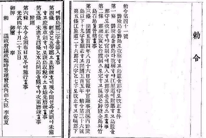
勅令第四十一號
第二條 郡廳位置는 台霞洞으로 定하고 區域은 鬱陵全島와 竹島 石島를 管轄할 事
光武四年十月二十五日 · 官報 第千七百十六號
Above: original scan · below: readable typeset reproduction (orthography partly modernized)
The documentary evidence behind both official narratives, with the accessibility of each original noted. Every source carries the other side's rebuttal. This document endorses neither claim.
VOTE Which story do you find more convincing? Naming rule This is the English edition, so the neutral name leads (Dokdo leads in Korean, Takeshima in Japanese) · The order of the two narrative sections below is randomized on every visitJapan's defence white paper again described the islets as inherent Japanese territory with the dispute unresolved; South Korea's defence ministry summoned the Japanese defence attaché and demanded the wording be corrected.
The Diplomatic Bluebook 2026, reported to cabinet, repeated that South Korea occupies the islets with no basis in international law, and recorded Japan's protest over South Korean military exercises there in 2025.
Japan's education ministry cleared high-school textbooks describing the islets as inherent Japanese territory illegally occupied by South Korea; Seoul summoned the Japanese embassy's minister and protested.
The last permanent civilian resident died; the registered residential population is now zero.
The lighthouse was upgraded from unmanned to manned.
⇄ The order of the two narrative sections below is randomized on every visit — this dossier takes no side, not even in sequence.
A chain of historical records (512→1454→1770) + Japan's own denials (1696·1877) + a modern act of sovereignty (1900) + postwar dispositions (1946).
Records that Silla's general Isabu subjugated Usan-guk, the maritime polity centered on Ulleungdo. Korea holds that Dokdo fell within Usan-guk's domain.
"The two islands of Usan and Mureung lie due east of Uljin in the sea… on a clear day they are visible from one another." Korea reads Usan as Dokdo and Mureung as Ulleungdo — the only distinct island visible from Ulleungdo with the naked eye is Dokdo.
During the Ulleungdo dispute (Takeshima Ikken), the shogunate queried Tottori domain, which replied that "neither Takeshima (Ulleungdo) nor Matsushima (Dokdo) belongs to Tottori." The shogunate then banned Japanese crossings to Ulleungdo in January 1696.
Japan's highest state organ, the Dajōkan, ruling on a land-registry query from Shimane, directed: "Concerning Takeshima (Ulleungdo) and one other island, know that they have no relation to our country." The attached sketch map depicts that "other island" — Matsushima, i.e., Dokdo.
Elevated Ulleungdo to Uldo County and defined its jurisdiction as "all of Ulleungdo, Jukdo, and Seokdo (石島)." Korea identifies Seokdo as Dokdo: 'stone island' → dialectal dok island → 石島 by meaning, 獨島 by sound.
Allied directive 677 (Jan 29) expressly excluded Ulleungdo, Liancourt Rocks, and Jeju from the area of Japanese governmental administration. Directive 1033 (Jun 22, the MacArthur Line) barred Japanese vessels from within 12 miles of the rocks.
A five-step structure: 17th-century inherent-territory thesis → 1905 reaffirmation of intent → postwar treaty settlement (SF Treaty + Rusk) → continuous administration → standing offer of ICJ adjudication.
The shogunate licensed the Ōya and Murakawa families to sail to Ulleungdo; en route they used Matsushima (Dokdo) as a waypoint, anchorage, and fishing ground. The 1667 Onshū Shichō Gōki is cited as evidence of early Japanese cognizance.
Prompted by sea-lion entrepreneur Nakai Yōzaburō's petition (Sept 1904), the cabinet found "no trace of occupation by another power" (terra nullius) and approved incorporation; Shimane Prefecture issued the notice. Fishing licenses and land-registry entries followed.
The final text names only three islands; Liancourt Rocks is silent. Draft history: US drafts of 1947–49 listed it among territories renounced to Korea → after political adviser Sebald's memoranda (Nov 1949) it moved to Japan's column → from the Aug 1950 draft it vanished from both lists → final silence.
The State Department's reply refusing Korea's request to add "Dokdo and Parangdo" to Article 2(a): the rocks were "never treated as part of Korea" and had been under Shimane's Oki branch office "since about 1905."
Japan proposed referring the dispute to the ICJ three times; Korea refused each time. ICJ jurisdiction requires both parties' consent — Korea has never accepted compulsory jurisdiction, so a unilateral Japanese filing cannot open a case.
After incorporation, Shimane licensed sea-lion hunting and collected land-use fees. In 2005 the prefectural assembly created "Takeshima Day" (Feb 22), marked annually (with a central-government vice-minister attending since 2013).
Where the two sides read the very same document in opposite ways — pick a reading and watch the highlighter move. The initial selection is random.
于山武陵二島 在縣正東海中 二島相去不遠 風日淸明 則可望見
"A distinct, distant island visible only on clear days" — from Ulleungdo, the only such island is Dokdo. The 1770 Dongguk Munheon Bigo states "Usan is what Japan calls Matsushima (Dokdo)."
'Usan' is an alias of Ulleungdo or a phantom island — there is no proof the two islands are Ulleungdo and Dokdo, and the 1770 gloss merely recycles An Yong-bok's unreliable testimony.
區域은 鬱陵全島와 竹島 石島를 管轄할 事
Stone island → dialectal dok island → 石島 by meaning, 獨島 by sound — the gazette transcribing the settlers' name. The 1906 report "Dokdo, under this county" completes the chain.
If Seokdo is Dokdo, why not write 'Dokdo' or 'Usando'? Some identify Seokdo as Gwaneumdo — and even granting it, there is no evidence of control around 1900.
Japan… renounces all right, title and claim to Korea, including the islands of Quelpart, Port Hamilton and Dagelet.
'including' introduces examples — you cannot list three thousand islands. Omission does not mean Japanese ownership, and nothing reverses SCAPIN 677.
The three named islands do not include Takeshima — and Korea's request to add it was expressly refused in the Rusk letter. The treaty therefore affirms it as Japanese.
Finding: truly neutral sources are rare. The accessible English-language legal literature converges on Korea's side, but each work carries caveats — the safest neutral construction is ① institutional explainers ② the naming record ③ the US 'no position' stance ④ both governments' materials presented side by side.
The decades-long line: the US "takes no position" on sovereignty over the Liancourt Rocks. In 2008 the Board on Geographic Names briefly reclassified the rocks as 'Undesignated Sovereignty' — reversed within a week on President Bush's instruction: "this is an issue for Korea and Japan to resolve" (KBS interview).
Google Maps labels the island 'Dokdo' in the Korean edition, '竹島' in the Japanese, and 'Liancourt Rocks' internationally (Oct 2012 policy change; Korea's foreign ministry protested). The CIA World Factbook likewise uses 'Liancourt Rocks' throughout.
Van Dyke (2007): applying ICJ case law, concludes Korea's title is "substantially stronger" (estoppel from the 1905 terra-nullius declaration, the taint of annexation, impossibility of protest, contiguity, a half-century of control) — while judging the rocks an Art. 121(3) 'rock' generating no EEZ. Fern (2005): using the neutral name throughout, finds Korea has demonstrated more "affirmative acts of sovereignty" — and that neither side has any incentive to adjudicate.
The Court's contentious jurisdiction rests entirely on state consent (special agreement / treaty clause / optional-clause declaration / forum prorogatum). Possessor states avoiding court is not unique to this island — Japan does the same over the Senkakus, Britain over the Falklands.
🇰🇷 MOFA Korea's Dokdo site: 11 languages — "clearly Korean territory historically, geographically and under international law; no dispute exists." 🇯🇵 MOFA Japan's Takeshima site: 12 languages — "inherent Japanese territory in light of historical facts and international law; Korea occupies it illegally" + the 28-page '10 Points' PDF.
Votes per hour. A surge is not hidden here — it is drawn.
One line, from people who voted. No replies. Your side and country are shown with it.
Vote first — this is where a vote gets its reason.
No lines yet.
Method and limits. Compiled 2026-08-24 via three parallel research tracks (Korean grounds / Japanese grounds / third parties). Every URL was verified live; Japanese government sites block automated access, so content was confirmed via browser and archives. Neither side disputes that these documents exist — the entire quarrel is interpretive. This dossier therefore pairs every document with a rebuttal, and leaves judgment to the reader. Three of the twelve carry a further answer to that rebuttal as well, attributed and visible as a change of speaker; all three are on Korean cards and no Japanese card carries one. A rebuttal that is answered and a rebuttal that stands are not the same thing, and the reader should be able to see which is which. Badges: original published = images or full text publicly available from an institution; copies published = original lost or not extant, transmitted in copies.
Editorial principles. ① Name order follows the language edition: Dokdo leads in Korean, Takeshima in Japanese; third-language editions prefer the neutral name (Liancourt Rocks). Where no neutral name exists, the controller's name leads, labeled as such. ② The order of the two narrative sections is randomized on every visit. ③ Every dispute is labeled with its de facto controller, and every source carries the other side's rebuttal.
伺之趣 竹島外一嶋之儀 本邦關係無之儀ト 可相心得事
明治十年三月廿九日 太政官
Typeset reproduction · original in the National Archives of Japan — view the scan
Original scan — the 1900 official gazette, public domain (Wikimedia Commons)
勅令第四十一號
第二條 郡廳位置는 台霞洞으로 定하고 區域은 鬱陵全島와 竹島 石島를 管轄할 事
光武四年十月二十五日 · 官報 第千七百十六號
Above: original scan · below: readable typeset reproduction (orthography partly modernized)
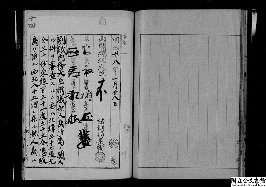
Cabinet decision on the ownership of the uninhabited island, Jan 28 1905, p.1 — public domain (Wikimedia Commons) · original in the National Archives of Japan
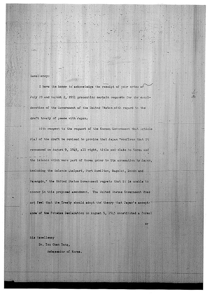
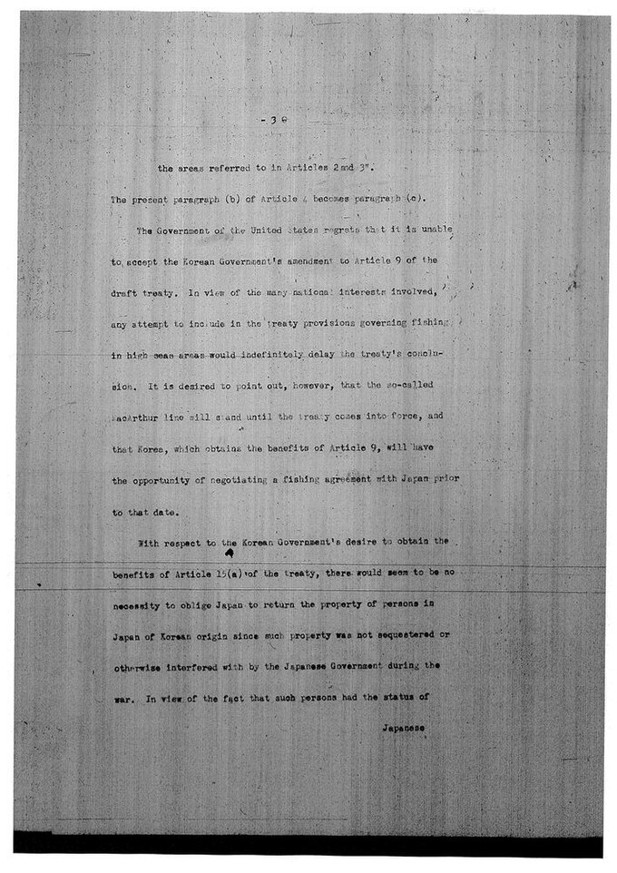
Original scan, pp. 1 & 3 — US government document, public domain (Wikimedia Commons)
DEPARTMENT OF STATE
WASHINGTON
August 10, 1951
As regards the island of Dokdo, otherwise known as Takeshima or Liancourt Rocks, this normally uninhabited rock formation was according to our information never treated as part of Korea and, since about 1905, has been under the jurisdiction of the Oki Islands Branch Office of Shimane Prefecture of Japan.
Dean Rusk
Above: original scans · below: the key paragraph, typeset — all 4 pages