Every other dossier on this site sets out two cases for owning a place. This one sets out two cases for not owning it. Bir Tawil is claimed by no state — and that is not an oversight but the exact arithmetic of a dispute about somewhere else. Each of Egypt's and Sudan's boundary positions on the Hala'ib Triangle — the next stretch of the same border, ten times the size — hands Bir Tawil to the other. Claiming Bir Tawil would mean conceding Hala'ib. What follows is each state's boundary case in its own documents, with the other's answer on every card. This page does not say who is right about Hala'ib, and it draws no single correct line.
VOTEWhat should become of this land?↓Naming rule This site's rule is that the name used by the state in effective control leads. Here no state is in effective control, so the rule has nothing to work on: Bir Tawil is the transliteration used in both states' own material and in the technical literature, and Arabic is the language of both. The spelling varies even in Arabic — بئر طويل in Modern Standard usage, بير طويل in the Egyptian form and in OpenStreetMap's alternate names. It means long well. One further note: this page does not use the phrase terra nullius in its own voice, for reasons set out at the end
Egypt's case rests onSudan's case rests onread in opposite ways
Current status — as of August 2026 Status as of 2026-08
De facto control none. No state administers Bir Tawil, no state maintains a post or a patrol inside it, and the boundary is unmarked on the ground. This is an absence evidenced by a small number of visitors' accounts, not by any state's declaration2026-08
De jure status claimed by no state, and not by inadvertence. Egypt's boundary position places it in Sudan; Sudan's places it in Egypt. No instrument of renunciation has been located on either side, and neither state names it in any filing before the Security Council retrieved for this page. No court or tribunal has ever ruled on this boundary2026-08
What is actually exercised the approaches from the north are controlled by Egypt — the route in from Aswan is reported to cross a declared military zone requiring prior permission — an account that comes from the 2014 flag-planter himself and has not been independently confirmed. Inside, the practical presence is artisanal gold prospecting and the armed groups around it, drawn from the Ababda and Bisharin, and from the Rashaida, who are not a Beja people and are not named in the 1902 instrumentunverified2026-08
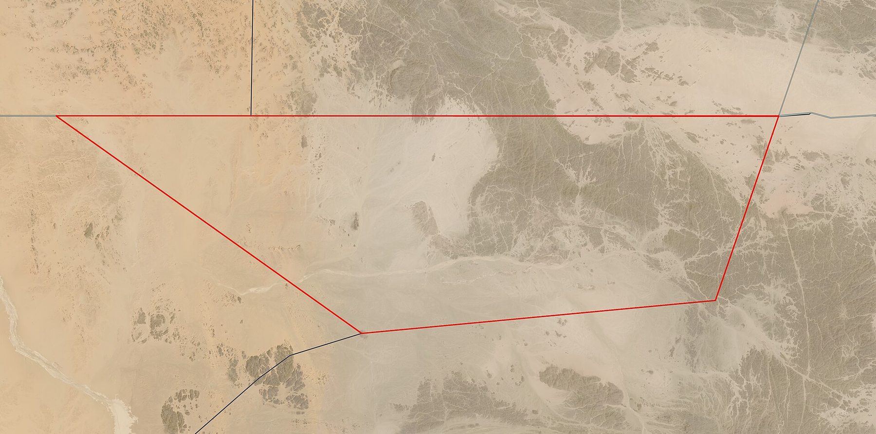
The land about 2,060 km²; the OpenStreetMap polygon, whose geometry is consistent with the 1962 US boundary study, computes to roughly 2,020 km² when measured for this page. A quadrilateral whose northern edge lies exactly on 22°00′N and runs some 94 km east to west. High point Jabal Hagar el Zarqa in the east — given as 662 m in the sources behind this page and as 714 m in OpenStreetMap, which is the sort of divergence to expect on unsurveyed ground. Hot desert, no surface water, over 200 km from the sea. The name means long well2026-08
Population no settlement, no census, and no permanent dwellings. The Ababda and Bisharin — both Beja peoples — cross it as herders and carriers, and are named in the 1902 instrument that created it. Gold-mining camps in and around the area are described by visitors as substantialunverified2026-08
Hala'ib — the territory this is actually about commonly given as 20,580 km² of Red Sea coast, roughly ten times the size and the next stretch of the same border — the two meet at a single point on the 22nd parallel, at about 34°04′48″E, where the 1902 line crosses it, and the coastal towns lie some 300 km further east — with towns at Hala'ib, Abu Ramad and Shalatin. Egypt has administered it since 1995 and runs it within the Red Sea Governorate; Sudan claims it and has never withdrawn the claim2026-08
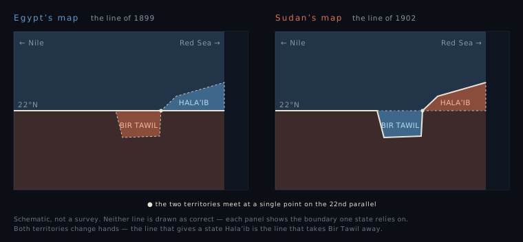
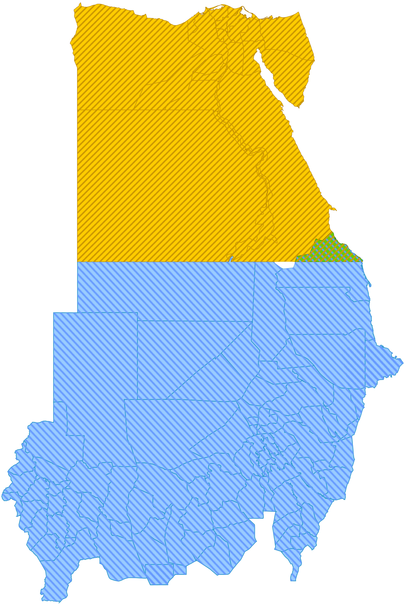
The two boundaries the 1899 political boundary runs 792 miles, of which all but the 38 miles of the Wadi Halfa salient follow the 22nd parallel; delimited throughout, never demarcated. The 1902 administrative boundary is 222 miles of straight-line segments. They diverge in two places: north of the parallel at Hala'ib, and immediately west of that, south of the parallel, at Bir Tawil2026-08
At the Security Council the 1958 Sudanese complaint is item 52 and is still live. Sudan asked for its retention by letter on 5 January 2026 (S/2026/13); Egypt replied on 6 February reaffirming its previous correspondence (S/2026/65); the Secretary-General recorded on 2 March that every item then subject to deletion, item 52 among them, would remain for a further year, and it was still listed in the addendum of 3 August 2026. The Council has not met on it since 21 February 19582026-03-02
On the procedure Sudan has stated in writing that it will accept a settlement, international arbitration or a ruling of the International Court of Justice on Hala'ib, and has asked the Council to compel Egypt to accept arbitration. Egypt does not answer the offer in any letter retrieved for this page; in 1995 it said it had believed the matter could be settled bilaterally. No third-party process has been agreed2026-08
June 2026 — violence at the border, not in Bir Tawil Egyptian aircraft and artillery struck artisanal gold-mining camps on 16–17 June; raids and mass arrests followed, with a rights group reporting 67 arrests at Wadi El Atri on 21 June and the Egyptian military reported to have announced 223 detentions — a figure this page could not trace to a primary announcement. Casualty figures and location are disputed: The camps were near Hala'ib and in Sudan's River Nile State; none of the reporting places them inside Bir Tawilunverified2026-06
Mada Masr23 killed; strikes about 50 km inside Egypt
Egypt's stated posture on Hala'ib reported in June 2026, quoting senior Egyptian officials, as a message that Egypt will not relinquish its sovereignty over the Halayeb and Shalateen Triangle. The same report says Egypt has repeatedly sought a Sudanese concession on the triangle in exchange for military support. Neither is confirmed from an Egyptian government sourceunverified2026-06-25
Sudan's civil war (April 2023 →) has not changed control of anything discussed here, but it has removed Sudan's capacity to press the Hala'ib claim by any means other than the annual letter. A report circulated in August 2025 that Sudan's leadership had directed the adoption of maps showing Hala'ib as Egyptian was officially denied by Sudan and is not treated as fact on this page; Sudan's letter of January 2026 re-asserts the 1958 complaintunverified2026-08
The claims by individuals several people say they have travelled to Bir Tawil and declared states there, and several more declared them without going. The journeys are self-reported and the men have accused one another of fabricating theirs. None has been recognised by any state or international organisation, and neither government has issued a formal response; a single reported remark by a Sudanese diplomat is the only government comment on record2026-08
In the data OpenStreetMap's relation for Bir Tawil carries no admin_level tag — checked live in August 2026 — and describes it as "Territory unclaimed by any country." Downstream libraries inherit the gap; one bug report is titled "Africa is a donut"2026-08
⚠ Five cautions.Bir Tawil cannot be discussed without Hala'ib, which is a live dispute over inhabited territory, and any accurate account necessarily displays two incompatible maps of it. This page draws no line as correct. It is not the last unclaimed land on Earth — Marie Byrd Land in Antarctica is unclaimed and far larger; the defensible formulation is the largest area outside Antarctica claimed by no state. Nor is it the only one: several small pockets on the Croatia–Serbia Danube border are unclaimed by both states for exactly the same reason — each state's boundary theory assigns them to the other. It is not uninhabited, and the popular framing that it is depends on not counting the people who cross it. This page does not call it terra nullius; the specialist sources dispute the label, on the ground that it is inside both states' claim systems rather than outside them. And the June 2026 casualty figures, the reported August 2025 map story, and the current posture of Egyptian access controls are all unresolved and are flagged as unverified above.2026-08
Change log
Egyptian strikes and mass arrests at artisanal gold-mining camps along the border. Casualty counts range from 23 to more than 50 across outlets, and which side of the line the strikes fell on is disputed. No reporting places them inside Bir Tawil.
The Secretary-General records that Sudan's 1958 complaint — item 52 — will remain on the Council's list of matters of which it is seized for a further year.
Egypt replies, reaffirming without restating: it wishes "to reiterate what Egypt has stated in all its communications to the Security Council regarding this matter."
Sudan writes to the President of the Security Council asking that the 1958 complaint be retained — as it has in every January for which a letter was retrieved for this page.
Reports circulate that Sudan's leadership directed the adoption of maps showing Hala'ib as Egyptian. Officially denied by Sudan; not treated as fact here.
Civil war begins in Sudan. Control of Hala'ib and the status of Bir Tawil are unchanged; Sudan's capacity to press the claim by any means but the annual letter is not.
A bug report titled "Africa is a donut" is opened against a geocoding library: because Bir Tawil belongs to no country, the library cannot place it on a continent.
Suyash Dixit reaches Bir Tawil, plants sunflower seeds and declares a kingdom. No state responds.
Jeremiah Heaton plants a flag. He says he obtained permission from the Egyptian military to make the journey; the account is his own. Neither government comments.
Jack Shenker and Omar Robert Hamilton reach Bir Tawil — the first documented visit — and deliberately make no claim.
After the attempt on President Mubarak's life in Addis Ababa, Egypt expels Sudanese police and administrators from Hala'ib. Sudan protests to the Council on 17 July and offers to go to arbitration or the International Court.
The Security Council meets on Sudan's complaint at its 812th meeting. Egypt announces a postponement; the Council takes no decision, and has not returned to the item since.
⇄ The order of the two narrative sections below is randomized on every visit.
🇪🇬 Egypt — the boundary is the 22nd parallel 6 sources
Egypt's position is that the only international treaty on this boundary is the Anglo-Egyptian Agreement of 19 January 1899, which places it on the 22nd parallel of latitude. Everything since — the 1902 line, the 1907 confirmation — was an Egyptian ministerial arrangement for administering nomadic tribes, and administration is not sovereignty. The Hala'ib Triangle lies north of the parallel and is therefore Egyptian; Egypt has administered it since 1995 and has not taken up Sudan's offer of arbitration in any letter read for this page. The same sentence that gives Egypt Hala'ib takes Bir Tawil away from it, and Egypt does not flinch from that: on Egyptian maps Bir Tawil is Sudanese.
"All the territories south of the 22nd parallel" 19 January 1899
The agreement established the Anglo-Egyptian condominium and drew the boundary as a parallel of latitude — a straight line across the Nubian desert, drawn without reference to anything on the ground. Bir Tawil's northern edge sits exactly on it: 22.0000°N, running about 94 km east to west. Hala'ib lies north of the parallel; Bir Tawil lies south.
The word "Soudan" in this Agreement means all the territories south of the 22nd parallel of latitude ... (the definition then attaches three conditions, turning on which territories had been evacuated, lost or reconquered) — Article I, Agreement between Her Britannic Majesty's Government and the Government of His Highness the Khedive of Egypt relative to the future administration of the Soudan, quoted from US Department of State, International Boundary Study No. 18 (1962), citing British and Foreign State Papers 91:19ff; the agreement was signed at Cairo on 19 January 1899 by Boutros Ghali and Cromer, per the text at Wikisource
Meaning
This clause is the hinge of Egypt's case and of Egypt's problem. The Article does not stop there — the definition attaches three conditions about which territories had been evacuated, lost or reconquered — and Sudan's reading of the agreement as later amended feeds on that complexity. If the parallel is the boundary, Hala'ib is Egyptian — and Bir Tawil is not. Egypt cannot invoke the sentence to hold the coast and decline to apply it to the desert, and it does not try to.
Sudan's answer
Sudan does not dispute the text. Its answer is that the 1899 agreement was later amended, not superseded: in its letter to the Security Council of 17 July 1995 Sudan's Foreign Minister put it as "the agreement concluded between the two parties in 1899 and amended in 1902 and 1907," which on Sudan's reading "provides that the Sudan has sovereignty over the territories and region of Halaib." At the Council in 1958 Sudan's representative made the same point more bluntly — and then conceded a great deal: "for practical purposes, the administrative boundary is the really important one. The 22nd parallel north is taken as the general boundary, and such modifications as were made in this arbitrary line were made for the obvious reason of avoiding the placing of portions of the same tribe under different administrations."
The 1902 line was an Egyptian minister's instrument 1899 · 1902 · 1907
The same ministry had already moved the Wadi Halfa salient across the parallel by a decree of 26 March 1899 — that one, the State Department notes, "in effect became an international line." The 1902 boundary did not. It was shortened in 1907, on a proposal from the Egyptian Intelligence Service approved by the Sirdar on 22 June: the western segment was cut back to run only as far as the 22nd parallel from Jebel Bartazuga, eliminating an indefinite triangle of land reaching toward the Nile. Confirmed unchanged on 10 October 1909. One source dissents on authorship, and it is outweighed. Keesing's contemporary account of the 1958 crisis attributes the 1902 decree to the Governor-General of the Sudan and puts an Egyptian Interior Ministry decree in 1907 "recognizing the new boundary." Against that stand the State Department's technical study and, in part, Sudan's own representative at the Security Council. He called the instrument of 25 July 1902 "a ministerial enactment" — not an act of a Governor-General — and he named the Egyptian Ministry of the Interior for the Wadi Halfa order of 26 March 1899 and for a confirming communication of October 1916. He did not name a ministry for the 1902 instrument itself. That narrows the conflict without closing it: the attribution Keesing's makes is contradicted by the party it would favour, but no source read for this page has Sudan calling the 1902 enactment Egyptian. Two smaller discrepancies do remain: Sudan's Council statement dates a further modifying enactment to later in November 1902 where the State Department gives the activating decree as 4 November, and it cites an Egyptian communication of October 1916 confirming the line, which the State Department does not mention.
The administrative boundary was first created by an arrete on July 25, 1902, and activated by a decree on November 4, 1902, both by the Egyptian Minister of the Interior. — US Department of State, International Boundary Study No. 18, 27 July 1962, p. 3
Meaning
Egypt's argument runs through the authorship. An arrangement made by an Egyptian minister for the convenience of tribal administration cannot move a boundary fixed by treaty between states — and in 1958 Egypt went further, telling the Security Council that the ministerial decisions positively help its case, because they are Egyptian acts.
Sudan's answer
Sudan's answer, from its own letter to the Secretary-General of 20 February 1958, is that these were not internal Egyptian acts at all: the territories "belong to the Sudan by virtue of agreements and treaties concluded between the Egyptian Government and the Sudan Government in 1902 and 1907. Since then the said territories have been under the exclusive administration and sovereignty of the Sudan." Egypt rejects that characterisation: on its account these were acts of one government, not agreements between two.
original publisheddocumentedThe 1902 arrêté and decree are not published online in full. What is published is the State Department's 1962 study, which worked from the texts and quotes their operative content, and the two governments' own characterisations of them in 1958 and 1995.One detail cuts against the Egyptian-authorship reading and belongs here: the State Department records in a footnote that the 1907–09 correspondence between the Survey Department and the Intelligence Service "was between British officials of these agencies."International Boundary Study No. 18 — PDFKeesing's Contemporary Archives, March 1958 — PDF
What a new state can and cannot inherit 1956–1995
Egypt made the same argument in 1958 in two forms. Keesing's records it maintaining that Sudan's transitional Constitution, "having been drawn up unilaterally, did not affect the 1899 agreement, which was the only international treaty on the subject." The State Department records the sovereignty limb: Egypt held that the territories north of the parallel "were never part of the Sudan but were actually under Egyptian sovereignty because they were formerly administered by a bilateral arrangement in which Egypt was a partner."
Since Sudan's accession to independence in 1956, and to date, all the territories situated to the north of the 22nd parallel have been under Egyptian sovereignty. This is a fact attested to by history and law. … They are nothing more than futile demands, contrary to a correct legal interpretation of the nature of the provisional arrangements made for the benefit of certain Sudanese tribes in a desire to strengthen links between the two peoples. — Amr Moussa, Minister for Foreign Affairs of Egypt, letter to the President of the Security Council, 10 July 1995 (S/1995/559, annex)
Meaning
The characterisation doing the work is provisional arrangements made for the benefit of certain Sudanese tribes. If the 1902 line was a favour, it can be withdrawn; if it was a boundary, it cannot. Note what Egypt is not arguing: it has never claimed Bir Tawil under the 1902 line, which would be the mirror move and would cost it the parallel.
Sudan's answer
Sudan's answer rests on what the people did rather than what the ministries wrote. From its 1958 letter: "The inhabitants of these territories are of Sudanese nationality. At no time did they vote in any Egyptian parliamentary election or plebiscite. Moreover, they have voted as Sudanese nationals in the Sudanese Parliamentary elections in 1953." On succession it relies on the Provisional Constitution's definition of the state as "all those territories which were included in the Anglo-Egyptian Sudan immediately before the commencement of this Constitution" — and on the fact, recorded by the State Department, that Nasser received Sudan's position on existing treaties on 3 January 1956 and Egypt "made no formal protest."
original publishedasserted by a governmentS/1995/559 is an Arabic original and the words quoted here are the United Nations’ English translation of it. On one point the two differ materially: Egypt wrote that its sovereignty over the territories north of the parallel is established historically and legally “before Sudan’s independence in 1956 and up to now”, and called that sovereignty continuous; the English renders it as running “since” independence. The Arabic edition of this page quotes the original.Egypt's letter of 10 July 1995 (S/1995/559)International Boundary Study No. 18 — PDFKeesing's Contemporary Archives, March 1958 — PDF
The exchange nobody accepted February 1958
Three published accounts, and they do not agree on which note carried the offer. The State Department's boundary study places it in the first note, of 1 February, and frames it as administration rather than territory: Egypt asked for the return of everything north of the parallel and "would reciprocate by turning over the Egyptian administered territory south of the 22nd parallel to Sudanese administration." Osman at the Council attaches it to the same memorandum. Keesing's contemporary summary instead puts it in "a second Note of Feb. 13, which asked for an early settlement and offered to exchange the Egyptian territory south of the 22nd parallel for the two Sudanese areas north of it." Sudan's own letter to the Secretary-General of 20 February walks through the Egyptian notes of 1, 13 (dated 9), 16 and 18 February and does not mention the offer at all. None of the four documents uses the name Bir Tawil.
While the Egyptian memorandum requested the handing over of the above two areas, it indicated the willingness of the Egyptian Government to hand over to the Sudan a region near the north-eastern frontier which had previously been ceded to Egypt when the Sudan-Egyptian frontier was reconstructed shortly after the conquest. — Yacoub Osman for Sudan, describing the Egyptian memorandum, at the Security Council's 812th meeting, 21 February 1958 (S/PV.812)
Meaning
This is the closest thing to an explicit act by either state about Bir Tawil, and it points the wrong way for the modern disclaimer: in February 1958 Egypt treated the area south of the parallel as something in its gift, and Sudan's own representative described it as land "previously ceded to Egypt." Whether what was offered was territory or only administration is what the accounts disagree about. The safe reading is the narrow one — Egypt put the area on the table — and the modern refusal should not be read back into it.
Sudan's answer
Sudan refused, and gave its reason at the Council: its Acting Foreign Minister had told the Egyptian Ambassador "that it was impossible for the Sudanese Government to cede territory which had constituted part of the Sudan for the last half-century merely on an exchange of notes." The refusal is about what Egypt wanted, not about what Egypt offered — Sudan declined to give up the northern areas and so never had to say what it thought of the desert offered for them. What Sudan did say about the desert itself was descriptive rather than dispositive: Osman called it a region "previously ceded to Egypt," which characterises the area without claiming or renouncing it. No filing located for this page has Sudan asserting or disclaiming the area in terms.
Egypt administered it on paper, and then stopped saying so 1958 → 2021
Read the tense. Keesing's in 1958 described the 1902 decree as one by which "two areas north of it were incorporated in the Sudan for administrative purposes and a third area south of it became Egyptian territory," and listed among the disputed places "a desert area of Egyptian territory to the west of the first area, lying south of the 22nd parallel." The State Department in 1962 wrote plainly of "the area administered by the United Arab Republic to the south of the 22nd parallel." The Factbook, decades later, records that Egypt no longer shows that administration. Nothing changed on the ground.
Sudan claims but Egypt de facto administers security and economic development of Halaib region north of the 22nd parallel boundary; Egypt no longer shows its administration of the Bir Tawil trapezoid in Sudan on its maps — CIA World Factbook, Egypt entry, "Disputes – international", 2021 edition (archived)
Meaning
The popular account treats Bir Tawil's unclaimed status as a century-old colonial accident. The official record does not support that. For at least the first sixty years the area south of the parallel was designated Egyptian-administered — by the 1902 instrument, by contemporary reporting and by an outside government's technical study. That is a fact about designation, not about authority exercised on the ground, for which there is no evidence in any period. No source located for this page explains why Egypt stopped showing the designation. What can be said is the sequence: the designation appears in official and technical sources into the 1960s and not afterwards, and the value of Hala'ib rose over the same period — coast, minerals, and from 1991 an offshore concession granted by Sudan over blocks including Hala'ib. That is chronology, not cause, and this page asserts no motive.
Sudan's answer
No Sudanese statement about the hardening of Egypt's designation was located for this page. What the record shows is the shape of Sudan's own filings: its letter of 20 February 1958 complains about the two areas north of the parallel and asks for nothing south of it, and no Sudanese filing since has named Bir Tawil. Its representative at the Council described the area south of the parallel as land "previously ceded to Egypt".
original publisheddocumentedThe 2021 Factbook wording is verified from the Internet Archive. By the November 2023 edition Egypt’s entry no longer carried an Egypt–Sudan dispute at all; the current edition could not be retrieved for this page.That description at the Council is a description rather than a claim, and on the Sudanese side there was no comparable position to abandon — a fact about the record rather than an argument Sudan has made.CIA World Factbook, Egypt, 2021 (Internet Archive)International Boundary Study No. 18 — PDFKeesing's Contemporary Archives, March 1958 — PDF
What the parallel is actually about 1995 → today
Hala'ib is commonly given as 20,580 km² of Red Sea coast with towns at Hala'ib, Abu Ramad and Shalatin — roughly ten times Bir Tawil. The two are not distant places. They meet at a single point on the 22nd parallel, at about 34°04′48″E, where the 1902 line crosses it: Bir Tawil to the south-west of that point, Hala'ib to the north-east. The coastal towns lie some 300 km further east. One line, one crossing, two anomalies back to back. Egypt has administered it since 1995; secondary accounts date the takeover to the weeks after the attempt on President Mubarak's life in Addis Ababa on 26 June that year, when it expelled Sudanese police and administrators. Egypt runs it within the Red Sea Governorate. It holds elections there — "all territory north of the 22nd parallel of latitude north falls within one of the electoral districts of Egypt," with polling for presidential, parliamentary and local elections and for referendums. It "rejects and does not recognize any action that the Sudan has taken, or might take in the future, to suggest that it has territorial rights north of the 22nd parallel," and calls such action a breach for which Sudan "can be held internationally responsible." On procedure Egypt says little. The nearest thing is a past-tense sentence in its letter of 10 July 1995, explaining why it had not itself gone to the Council: it "sincerely believed that the historical relations between the Egyptian and the Sudanese peoples would enable a solution to the problem to be found by means of bilateral negotiations." That is an explanation of Egypt's own restraint rather than an answer on arbitration. Sudan's reply a week later says it declares its readiness "once again," so the offer was not new even then, and no Egyptian letter read for this page takes it up.
the international border between Egypt and the Sudan runs along the 22nd parallel of latitude north. This fact is based on a clear and well-established legal basis, namely, the agreement that was concluded in January 1899 … It is well-established that Egypt has sovereignty and jurisdiction over its land and maritime territory north of that line, and that the territory of the Sudan includes those lands that are to the south of the 22nd parallel of latitude north. — Egypt, letter to the Secretary-General and the President of the Security Council, 26 March 2018 (S/2018/270)
Meaning
Hala'ib is the reason this page exists. Every sentence either state has ever written about the 22nd parallel is aimed at the coast; Bir Tawil is the shadow that sentence throws to the west. And the 2018 letter is the nearest thing to a formal Egyptian statement about Bir Tawil in existence: in saying that Sudan's territory includes the lands south of the parallel, Egypt puts its disclaimer in writing, at the Security Council, without ever naming the place.
Sudan's answer
Sudan calls it occupation and asks for a neutral forum. In its reply of 17 July 1995 it "declares once again that it is ready and determined to accept the principle of a settlement or international arbitration or even a ruling by the International Court of Justice concerning the dispute over Halaib," and asks the Council "to compel Egypt to accept the principle of international arbitration." It renewed the call in March 2018, invoking "the resolution of conflicts by peaceful means, including arbitration, something for which the Government of the Sudan has called should the Egyptian Government fail to end its occupation of the triangle." It also asks for the joint commission on Hala'ib to resume work, for withdrawal, and for the lifting of what it calls a blockade on the inhabitants. On the electoral district the two letters flatly contradict each other: Sudan's of 9 March 2018 says Egypt had "for the first time, designated the Hala'ib region as an electoral district," and Egypt's reply says polling there "is not something that is unprecedented." This page does not resolve which is right.
🇸🇩 Sudan — the boundary is the administrative line of 1902 6 sources
Sudan's position is that the 1899 agreement was amended in 1902 and 1907 by instruments made between the two governments, and that what those instruments produced is the operative boundary. Hala'ib lies north of the 22nd parallel and south of the 1902 line, was administered from Khartoum for half a century, and its people voted as Sudanese in 1953; it is therefore Sudanese. Sudan has offered arbitration and the International Court, and has kept its 1958 complaint alive at the Security Council by letter in the first week of January in every year for which a letter was retrieved here. The same line that gives Sudan Hala'ib gives Bir Tawil to Egypt — and on Sudanese maps that is where it is.
The line that follows people 25 July · 4 November 1902
The stated purpose was "to facilitate the administration of nomadic tribes along the international boundary and to retain the continuity of certain tribal areas." The result is 222 miles of straight-line segments running from the 22nd parallel at about 33°10′E east to Bi'r Shalatayn and the Red Sea, delimited but never demarcated on the ground. It departs from the parallel in exactly two places: north of it near the coast, where Hala'ib was placed under Sudanese administration, and immediately west of that, south of the parallel, where Bir Tawil was placed under Egyptian administration. Bir Tawil is the only stretch where the 1902 line runs south of the 1899 line.
The principal tribes involved, were the Bisharin Bedouins under the administration of the Sudanese Government and the Ababda Bedouins under the administration of the Egyptian Government, except the tribe of the Melikabe-Kibli with the well at Bir-Bekhwat which would be under the Sudanese Government. — US Department of State, International Boundary Study No. 18 (1962), footnote 7, summarising the 1902 arrêté and decree
Meaning
The 1902 line is the reason Bir Tawil exists as a category at all. It is also the reason the land is not empty in the sense the flag-planters need it to be: the line was drawn around the movements of the Ababda, who are named in the founding instrument — as is one other group, the Melikabe-Kibli, together with their well at Bir-Bekhwat.
Egypt's answer
Egypt's answer is that the instrument's own words defeat the use Sudan makes of it: a boundary created to administer nomads, by an Egyptian minister, is what it says it is. In 1995 Egypt called the 1902 arrangements "provisional arrangements made for the benefit of certain Sudanese tribes." At the Council in 1958 it went further and claimed the instruments for itself — its representative said there was no need to argue the law, adding that "the Egyptian ministerial decisions on the administration of the area" "incidentally, buttress the Egyptian case."
The same footnote records two further facts Sudan relies on. Sudan on independence "made known that it reserved the right to determine whether it would be bound by any treaty or agreement made on its behalf prior to independence." And on 3 January 1956 President Nasser received a letter from Sudan's Prime Minister setting out that position, "to which the Egyptian Government made no formal protest." On the administrative question the same study concludes that "for most purposes the states concerned had treated the two territories as being under Sudanese administration for approximately a half century."
all those territories which were included in the Anglo-Egyptian Sudan immediately before the commencement of this Constitution — Provisional Constitution of the Sudan, quoted in US Department of State, International Boundary Study No. 18 (1962), footnote 9
Meaning
Sudan's case is a succession case. What it inherited was the territory as administered, and the administration ran to the 1902 line, undisturbed, from 1902 to 1956. Note the attribution: the half-century sentence is the State Department's assessment of what the two states did, not a concession by either of them.
Egypt's answer
Egypt's answer, recorded by Keesing's in 1958, is that a constitution is not a treaty and cannot make one: Sudan's transitional Constitution, "having been drawn up unilaterally, did not affect the 1899 agreement, which was the only international treaty on the subject." No Egyptian statement addressing the absence of protest in January 1956 was located for this page. What Egypt does assert, in 2018, is the conclusion: "the international border between Egypt and the Sudan runs along the 22nd parallel of latitude north."
Sudan takes it to the Security Council 20–21 February 1958
Two territories, not one: the north-eastern corner above 22°N, and the area north of Wadi Halfa comprising Saras, Debeira and Faras — about 140 square miles that the Aswan High Dam would later flood. The Council met the following day, 21 February, at its 812th meeting. Sudan's representative Yacoub Osman argued that the same boundaries "have remained, on the whole, undisputed for nearly sixty years" and that "for practical purposes, the administrative boundary is the really important one."He did not stop there, and what he said next is the strongest passage in the 1958 record for Egypt:"The 22nd parallel north is taken as the general boundary, and such modifications as were made in this arbitrary line were made for the obvious reason of avoiding the placing of portions of the same tribe under different administrations." He also called the 1902 instrument "a ministerial enactment" — Egypt's characterisation, not the "agreements and treaties concluded between the Egyptian Government and the Sudan Government" of his own Prime Minister's letter of the previous day. Egypt announced the same day that it would postpone the frontier question until after the Sudanese elections. The Council took no decision. It has not met on the item since.
These two territories belong to the Sudan by virtue of agreements and treaties concluded between the Egyptian Government and the Sudan Government in 1902 and 1907. Since then the said territories have been under the exclusive administration and sovereignty of the Sudan. The inhabitants of these territories are of Sudanese nationality. At no time did they vote in any Egyptian parliamentary election or plebiscite. — Prime Minister Abdulla Khalil, letter of 20 February 1958 annexed to Sudan's letter to the Secretary-General (S/3963)
Meaning
This is the founding document of the whole dispute, and it is worth noticing what it does not contain. Sudan complains about two areas north of the parallel. It does not ask for the area south of it, then or ever. And Sudan's two documents of that week do not describe the 1902 instrument the same way.
Egypt's answer
Egypt's representative Omar Loutfi declined to argue the law at all, and said why: "There is really no point in referring here to the agreement relative to the administration of the Sudan concluded at Cairo between Egypt and Great Britain in 1899 or to the Egyptian ministerial decisions on the administration of the area which, incidentally, buttress the Egyptian case." He denied there were Egyptian armed forces in the area — "We have frontier guards, who are needed to maintain order and security" — objected to Sudan's use of the word aggression, and called the complaint hasty and connected with Sudanese domestic politics, a matter on which he said the Council was "entirely without jurisdiction."
original publisheddocumentedS/3963 is a digitised 1958 typescript whose scan carries heavy OCR damage; quotations from it restore obvious mis-scans of ordinary words and add, remove and reorder nothing. The verbatim record of the 812th meeting is a typeset Official Record and is quoted as printed.Osman spoke English. Loutfi spoke French, and his words are quoted from the United Nations English translation printed in the same record.Sudan's letter of 20 February 1958 (S/3963)Verbatim record, 812th meeting, 21 February 1958 (S/PV.812)
How Egypt came to hold Hala'ib 1991–1995
The trigger was oil. Sudan agreed terms in principle with the Canada-based International Petroleum Corporation on 15 August 1991 over blocks including Hala'ib, signed in January 1992; the row broke out that February. Sudan complained to the Council repeatedly in 1993 and 1994. After the attempt on President Mubarak's life in Addis Ababa on 26 June 1995, Egypt expelled Sudanese police and administrators, and Sudan's protest of 17 July followed. Sudan's own filings date the occupation to 1995.
Egypt's attempts to alter the demographic structure of the region and expel its inhabitants by applying a policy of fait accompli will not give it legal or historical sovereignty over this Sudanese territory, especially after the decisive events that took place at the beginning of the conflict in the region. — Ali Osman Mohamed Taha, Minister for Foreign Affairs of Sudan, letter to the President of the Security Council, 17 July 1995 (S/1995/587, annex)
Meaning
Everything on this page after 1958 follows from the moment the coast acquired a price. Bir Tawil's status has never changed, because nothing there has ever acquired one.
Egypt's answer
Egypt's answer, in the letter this one was replying to, is that there was nothing to occupy: "Since Sudan's accession to independence in 1956, and to date, all the territories situated to the north of the 22nd parallel have been under Egyptian sovereignty." It treats the Sudanese complaints as propaganda "artificially aggravating the situation, purely for domestic purposes," and says the proper route is bilateral negotiation. Egypt's letters to the Council in the decades since do not restate the argument; they refer back to it.
original publishedasserted by a governmentThe 1991–92 concession dates come from secondary accounts and were not verified against a primary instrument for this page. Both governments' 1995 letters accuse the other of serious wrongdoing; this card quotes each on the territorial question only.The expulsion of Sudanese police and administrators, and its dating to June 1995, come from secondary accounts. The two 1995 letters record Sudanese complaints of expulsion and demands for withdrawal but do not date the takeover.S/1995/587’s cover sheet is marked English, but the annexed letter from Sudan’s Foreign Minister carries “original: Arabic”. The words quoted here are therefore also a United Nations translation, and the Arabic edition of this page quotes the original.Sudan's letter of 17 July 1995 (S/1995/587)Egypt's letter of 10 July 1995 (S/1995/559)
The letter that keeps 1958 alive 5 January 2026
The Council's own procedure explains why the letter has to be written. Items not considered at a formal meeting for three years are listed as subject to deletion, and "will be deleted unless a Member State notifies the President of the Security Council by 28 February 2026 that it wishes an item subject to deletion to remain on the list." Item 52 reads: "Letter dated 20 February 1958 from the representative of the Sudan addressed to the Secretary-General (21 February 1958; 21 February 1958)" — first taken up and last considered on the same day, sixty-eight years ago. On 2 March 2026 the Secretary-General recorded that, "at the request of Member States and with the concurrence of the Security Council," every item then subject to deletion — item 52 among them — would remain for one additional year. The addendum does not name Sudan or single the item out. Nine such letters were located for this page, and all nine fall in the first week of January: 5 January 2017 (S/2017/7), 3 January 2019 (S/2019/3), 2 January 2020 (S/2020/9), 4 January 2021, 6 January 2022, 4 January 2023, 3 January 2024, 6 January 2025 and 5 January 2026. Seven were read in full; the 2019 and 2020 letters are identified by symbol and date in Egypt's replies to them. They are worded almost identically, and what changes is the item's number as the list around it is edited — 56 in 2017 and 2019, 59 in 2020, 55 in 2021, 53 in 2022 and 2023, 55 in 2024, 54 in 2025, 52 in 2026. It falls and rises, because items are added to the Council's list as well as deleted from it. No letter was located here for 2018, which is a gap in this page's retrieval rather than a finding about Sudan.
the Government of the Sudan wishes to have retained, on the list of matters of which the Security Council is seized, item 52 … namely the item entitled "Letter dated 20 February 1958 from the representative of the Sudan addressed to the Secretary-General" (S/3963). — Letter dated 5 January 2026 from the Permanent Representative of the Sudan to the President of the Security Council (S/2026/13)
Meaning
This is the load-bearing fact of the page. Sudan's claim to Hala'ib is not dormant and not rhetorical: it is maintained by an administrative act on a fixed annual schedule, and it has survived a coup, a partition and a civil war. And because the Hala'ib claim and the Bir Tawil disclaimer are the same claim, Sudan's refusal of Bir Tawil is renewed on the same schedule. The refusal is not neglect; it is maintained.
Egypt's answer
Egypt's replies to the retention letters — 13 February 2017, 23 January 2019, 20 January 2020, 27 January 2025 and 6 February 2026 — reiterate its standing position rather than restate it. The letter of 6 February 2026 says in full only that Egypt wishes "to reiterate what Egypt has stated in all its communications to the Security Council regarding this matter." The Egyptian letter that does state the argument, of 26 March 2018 and quoted on the Egyptian card above, is not part of this exchange at all: it answers a different Sudanese letter, about Egypt's administration of Hala'ib.
What Sudan says about Bir Tawil: nothing, in writing 1958 → 2026
Sudan's filings before the Council, from 1958 to the letter of January 2026, concern the territories north of the parallel. Bir Tawil is not named in any of them. The refusal is expressed only cartographically, and the same is true in reverse of Egypt. No instrument of renunciation has been located on either side. What exists is two sets of official maps that each place the trapezoid in the other country.
On Egyptian maps, Bir Tawil is shown as belonging to Sudan. On Sudanese maps, it appears as part of Egypt. — Jack Shenker, “Welcome to the land that no country wants,” The Guardian, 3 March 2016
Meaning
This is why the page treats the disclaimers as latent claims rather than absences. Each state holds a claim it declines to activate, because activating it forfeits something ten times larger. "Unclaimed" describes a revealed preference, not a legal vacuum.
Egypt's answer
Egypt's position is the mirror image and is equally unwritten, with one exception that cuts against it: the exchange offered in February 1958, when Egypt put the area south of the parallel on the table — though as the card on that offer sets out, the accounts disagree over whether what was offered was territory or only administration.
copies publishedThe two map sentences are quoted from the author's own republication of the article. The underlying assertion — what appears on each state's official maps — is a journalist's account, not an inspection of official cartography, which this page has not carried out.On the age of the two positions: Egypt's disclaimer is younger than its claim, because of the February 1958 offer, while Sudan made no equivalent offer then and has made none since, so its claim and disclaimer are the same age. This page draws no conclusion from that.Jack Shenker, "Welcome to the land that no country wants"Sudan's letter of 5 January 2026 (S/2026/13)
The people the line was drawn around 3 sources
Neither state claims Bir Tawil, and no third party claims it either. But the reason the 1902 boundary bends at all is that people were already crossing it, and they are named in the instrument that created the anomaly. This section is here because the two-sided format would otherwise delete them, and because every popular account of Bir Tawil depends on the land being empty.
Named in the founding document 1902
The Ababda and the Bisharin — both Beja peoples, the Ababda based on the Egyptian side and the Bisharin on the Sudanese — are the reason the 1902 line exists. The State Department's summary of the instrument names them, and names one exception by tribe and by well: the Melikabe-Kibli, with the well at Bir-Bekhwat, to be under the Sudanese Government. Jack Shenker's account of the same document adds the detail that Jebel Bartazuga, the mountain the line runs to, "was home to the nomadic Ababda tribe, which was considered to have stronger links with Egypt than Sudan."
What it establishes — and its limits
It establishes prior and continuing use, recorded in the founding instrument itself rather than inferred. The border exists because of these people. Its limits: the document names them as objects of administration, not as parties; it is a colonial instrument written about them and not by them; and none of it amounts to a third claim to the territory. This page has found no organised movement advancing one, and does not invent a claimant to fill out the format.
Although it lacks any permanent dwellings today, this section of desert is still used by members of the Ababda and Bisharin tribes who carry goods, graze crops and make camp within the sands. (Not the least of our failures was that we did not manage to speak to any of the peoples who had passed through Bir Tawil before we arrived.) Their ties to the area may be based on traditional rather than written claims – but Bir Tawil is not any more a "no man's land" than the territory once known as British East Africa … — Jack Shenker, The Guardian, 3 March 2016, on his and Omar Robert Hamilton's January 2011 journey
Shenker sets the argument against its own history, quoting the British commissioner Sir Charles Eliot on East Africa: "I cannot admit that wandering tribes have a right to keep other and superior races out of large tracts … merely because they have acquired the habit of straggling over far more land than they can utilise." His verdict is the title of this card. Jeremiah Heaton, who planted a flag there in 2014, is reported to have told the Guardian the opposite — that the Bedouin do not enter Bir Tawil because it is too dry, and that the few people he spoke to welcomed his plans, while conceding he spoke to only a handful. That account reaches this page through the research behind it and could not be re-read at source; theguardian.com is not retrievable from this environment.
What it establishes — and its limits
It establishes that the land has users, from the two first-hand accounts that address the question directly, and that the better-documented of them says so. Other visitors — 2017, 2019, 2020, 2024 — describe presence without addressing traditional use. Its limits are large and should not be smoothed over: the two eyewitnesses contradict each other; both are outsiders on short visits; and Shenker's own parenthesis is the most important sentence here — neither account rests on speaking to the people concerned. This page is in the same position, one step further removed.
Who is actually there: the gold economy 2019 → 2026
The people present in and around the trapezoid today are artisanal gold prospectors, and the armed groups escorting and preying on them are drawn mainly from the same Beja communities the 1902 line was drawn around. Visitor accounts from 2019 and 2020 describe substantial mining camps and being escorted by armed Ababda men; tour operators reported mining settlements and, in 2024, weapons dealers. In June 2026 Egyptian aircraft and artillery struck artisanal mining camps in the border zone and Egyptian forces made mass arrests. Those strikes were reported near Hala'ib and in Sudan's River Nile State — not inside Bir Tawil — and which side of the line they fell on is disputed, as are the casualty figures. No mining licence has been recorded inside Bir Tawil itself.
What it establishes — and its limits
It establishes that the absence of a state is not an absence of people, of economy or of violence, and that the violence is inflicted on the communities named in the 1902 document. Its limits: the camp and escort accounts are travellers' and tour operators' reporting, attributed here rather than asserted; the June 2026 casualty counts conflict sharply between outlets; and the location dispute is not a detail but the whole question — where exactly the border runs is what nobody has ever demarcated.
Where the two readings actually collide 3 passages
Three passages that both states quote. Select a reading to see how each side uses the same words.
① One treaty, or a treaty as amended?
Article I, 1899: "The word 'Soudan' in this Agreement means all the territories south of the 22nd parallel of latitude ..." Sudan, 1995: "The agreement concluded between the two parties in 1899 and amended in 1902 and 1907 provides that the Sudan has sovereignty over the territories and region of Halaib." Egypt, 1995: the Sudanese claims are "contrary to a correct legal interpretation of the nature of the provisional arrangements made for the benefit of certain Sudanese tribes in a desire to strengthen links between the two peoples." Sudan, 1958: the territories belong to Sudan "by virtue of agreements and treaties concluded between the Egyptian Government and the Sudan Government in 1902 and 1907."
There is one international instrument here and everything else is domestic. The 1899 agreement was made between Egypt and Great Britain; the 1902 arrêté and decree were issued by an Egyptian minister, and the 1907 change was proposed by the Egyptian Intelligence Service and approved by the Sirdar. A state cannot cede territory by internal administrative order to a territory it was itself co-administering. Sudan's own phrase gives the game away — it calls them agreements between "the Egyptian Government and the Sudan Government" in 1902, when there was no Sudanese government to conclude anything with.
The instruments are amendments, and both states treated them as binding for half a century. Sudan does not need the 1902 line to be a treaty; it needs it to be what the two administrations actually operated, which the State Department confirms: for most purposes the territories were "treated as being under Sudanese administration for approximately a half century." And Egypt cannot call the 1902 acts merely internal in one breath and tell the Security Council in the next that "the Egyptian ministerial decisions on the administration of the area … buttress the Egyptian case."
Both parties are quoted from their own filings. The characterisations — provisional arrangements, agreements and treaties — are each side's own words for the same documents, and neither is adopted here.
② 1956: what passed at independence
Provisional Constitution: the state comprises "all those territories which were included in the Anglo-Egyptian Sudan immediately before the commencement of this Constitution." State Department: on 3 January 1956 Nasser received Sudan's position on existing treaties, "to which the Egyptian Government made no formal protest" — and the same study records Egypt's answer, that the areas north of the parallel "were never part of the Sudan but were actually under Egyptian sovereignty." Keesing's, 1958: Egypt maintained that the transitional Constitution, "having been drawn up unilaterally, did not affect the 1899 agreement, which was the only international treaty on the subject." Sudan, 1958: the inhabitants "have voted as Sudanese nationals in the Sudanese Parliamentary elections in 1953" and "at no time did they vote in any Egyptian parliamentary election or plebiscite."
A state cannot enlarge itself by writing its own constitution. Whatever Khartoum declared in 1956, it could not convert an administrative convenience into a boundary, and silence in the face of a unilateral document is not consent to it. As for the elections: voting rolls are administrative records too. They show who was being administered, which nobody disputes, not who held sovereignty, which is the question.
Succession takes the territory as it was administered, and Egypt watched it happen. The administration ran to the 1902 line from 1902 to 1956 without interruption. Egypt received Sudan's statement of position on 3 January 1956 and did not protest, and did not raise the question at all until the plebiscite of February 1958 gave it a reason. The people of the disputed areas were Sudanese nationals who had already voted twice as Sudanese and never once as Egyptians.
The 1953 elections and the Provisional Constitution concern Hala'ib and the Wadi Halfa area, which had inhabitants. They do not concern Bir Tawil, which had no settled population then and has none now — which is why neither state has ever argued about it in these terms.
③ 21 February 1958: both sides claim the same instruments
Osman (Sudan): the boundaries have "remained, on the whole, undisputed for nearly sixty years" … "for practical purposes, the administrative boundary is the really important one." Loutfi (Egypt): "There is really no point in referring here to the agreement … concluded at Cairo between Egypt and Great Britain in 1899 or to the Egyptian ministerial decisions on the administration of the area which, incidentally, buttress the Egyptian case." Loutfi: "there are no Egyptian armed forces in that area. We have frontier guards, who are needed to maintain order and security." Sudan's letter: "a breach of Sudanese sovereignty … may develop into armed conflict."
Egypt declined to litigate because it did not need to. Loutfi's point was that the Council was the wrong forum and the complaint was domestic politics: Sudan had gone to New York before exhausting the peaceful means in Article 33, on the eve of its own elections. The remark about the ministerial decisions is not a concession — it is the observation that even the instruments Sudan relies on are Egyptian acts, made by Egypt, and that a party does not strengthen its case by citing the other side's paperwork.
Egypt refused to argue the law in the one forum where it would have been recorded. Sudan came with documents, dates and a nationality argument; Egypt came with an assurance of brotherhood and a postponement. And in the same breath in which it said the 1902 decisions need not be discussed, it claimed them. The Council heard the case once, took no decision, and has not returned to it — which is the outcome Egypt's approach was designed to produce.
Osman spoke English; Loutfi spoke French and is quoted from the United Nations translation, which matters more than usual here. The French column of the same record reads that the Egyptian ministerial decisions "qui, notamment, appuient le bien-fondé de la thèse égyptienne" — notably support the Egyptian case. The United Nations English renders notamment as "incidentally," which tilts the sentence the other way, and Sudan's reading below turns on exactly that tilt. Neither reading is endorsed here.
Outside the two states 6 sources
No international body has ever determined anything about this boundary. Sudan has offered arbitration and the International Court; Egypt does not take it up in the letters read here. What exists outside the two capitals is technical, cartographic and journalistic — and one category that simply fails to apply.
The technical source, and its recommendation 27 July 1962
… it is preferable to show both the international and administrative boundaries on a map (in the latter case the boundary should be labeled "Administrative Boundary"), and … where the map scale does not warrant or permit the use of both … the administrative boundary should be shown. — US Department of State, Office of the Geographer, International Boundary Study No. 18, Conclusion
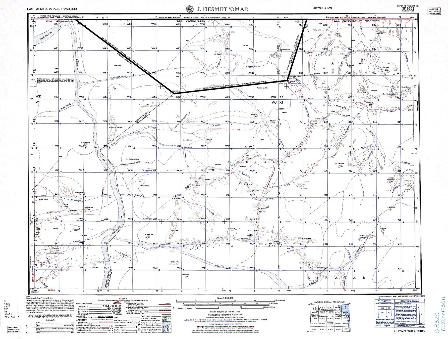
Seven pages of text and no map. It gives the international boundary as 792 miles, the administrative boundary as 222 miles, the Wadi Halfa salient as slightly under eight miles wide at its base and reaching 22°12′12″N, and records that the boundary is "delimited throughout" but "has not been demarcated." OpenStreetMap's polygon of Bir Tawil is consistent with its geometry — the western vertex sits at 33°10′E and the southern at Jebel Bartazuga — though the relation carries no source tag, so the link is inference rather than documentation. Measured for this page the polygon computes to about 2,020 km², against the commonly published figure of 2,060.
Value / limits
It establishes the documentary chain — dates, authorities, purposes, tribes and wells — better than any other public source, and it is a technical study without a legal opinion. Its limits: it is a United States government document, produced during the Cold War, and its cartographic recommendation is not neutral in effect. Told to pick one line, it picks Sudan's. That is a mapping judgment about which line traffic and people actually follow, not a view on title, and this page does not treat it as one.
One publication, two entries, and a reversal 2021 edition
Sudan claims but Egypt de facto administers security and economic development of Halaib region north of the 22nd parallel boundary; Egypt no longer shows its administration of the Bir Tawil trapezoid in Sudan on its maps — CIA World Factbook, Egypt entry (archived 2021)
The Sudan entry of the same edition carries the same Hala'ib clause, differing by one word — "the Halaib region" — and no Bir Tawil clause at all; in both entries the clause sits inside a longer list of disputes rather than standing alone. Note also where the Factbook puts the place: "the Bir Tawil trapezoid in Sudan." By the November 2023 edition the asymmetry had reversed. Egypt's "Disputes – international" field no longer listed an Egypt–Sudan dispute at all, only Egypt–Gaza and Egypt–Ethiopia. Sudan's still carried it, now under an explicit heading: "Sudan-Egypt: Sudan claims, but Egypt de facto administers, security and economic development of the Halaib region north of the 22nd parallel boundary."
Value / limits
It establishes that an outside government's reference publication described Bir Tawil as something Egypt used to show on its maps and stopped showing, and placed it in Sudan — and that between 2021 and 2023 the same publication dropped the Egypt–Sudan dispute from Egypt's entry while keeping it in Sudan's. Its limits: the Factbook has no legal effect, its "in Sudan" is an editorial convenience and not a determination, and an editorial decision to shorten a list is not evidence of anything either state did. The 2021 wording quoted at the top of this card is a retired text, not a live source.
Members of the United Nations which have or assume responsibilities for the administration of territories whose peoples have not yet attained a full measure of self-government … to transmit regularly to the Secretary-General … information … relating to economic, social, and educational conditions in the territories for which they are respectively responsible — Charter of the United Nations, Article 73 and Article 73(e)
Bir Tawil is not on the United Nations list of Non-Self-Governing Territories, and the reason is structural rather than substantive. Chapter XI attaches its obligations to Members that administer territories; the listing mechanism works through information those administering Powers transmit. Bir Tawil has no administering Power to transmit anything. When the flag-planting reached the press in 2014, a spokesman for the Secretary-General told the Washington Post that defining a country's borders was not the United Nations' role.
Value / limits
It establishes that the UN's silence is a gap in a mechanism, not a finding. Absence from the list says nothing about status. Its limits: the structural reading above is this page's reading of the Charter text quoted, not an official interpretation, and no United Nations organ appears ever to have been asked to say anything about Bir Tawil. On Hala'ib the Council has been asked, once, in 1958, and took no decision.
The hole shows up in the data, not on the map 2013 → 2026
Since Bir Tawil isn't part of any country, country-coder doesn't know that it's part of Africa. We should add a region just to fill in this hole. — country-coder issue #27, "Africa is a donut," opened 17 July 2020
OpenStreetMap relation 3335661 carries boundary=administrative and description:en=Territory unclaimed by any country. and — checked live for this page in August 2026, at version 52 — no admin_level tag at all. That absence is deliberate and contested: the tag was added and removed repeatedly in the relation's early history, at versions 3, 7, 8 and 15. On 14 July 2014, days after the flag-planting reached the press, the relation was renamed "Kingdom of North Sudan"; it was reverted three weeks later, renamed again through a run of edits on 24 February 2016 and reverted a fortnight after that, and renamed a third time on 7 October 2022 as "Finnish Sahara Territory" — with admin_level=3 attached — and reverted eighty-five minutes later. The relation also carries timezone=Africa/Cairo, which is a practical tag for software and says nothing about status.
Value / limits
It establishes what mapmakers do when no state supplies an answer: they leave the field blank, and every system downstream inherits a hole, up to and including the shape of a continent. Its limits: mapping data is not a legal source and OpenStreetMap is edited by volunteers — the very history quoted here shows the relation being vandalised three times. Note also the correction to a widely repeated claim: standard OSM rendering draws boundaries as lines and never fills country polygons, so there is no visible uncoloured hole on the map. The hole is in the data.
Why the flags fail, and why "terra nullius" is the wrong word 16 July 2014
Rather than terra nullius, this may be more like a territorial version of Schrodinger's cat. — Chris Borgen, Opinio Juris, 16 July 2014
Three independent reasons are given in the literature, any one of which is sufficient. First, only states are capable of acquiring territorial sovereignty — Anthony Arend of Georgetown told the Washington Post in 2014 that under international law only states can assert sovereignty over territory. Secondary accounts render his words in indirect speech and this page could not reach the original, so it is given as reported substance rather than as a quotation. Second, occupation as a mode of acquisition presupposes unappropriated land, and Bir Tawil is not unappropriated but doubly appropriated: each state places it inside its own boundary system and assigns it to the other. Third, even if the mode were open, Borgen quotes James Crawford: "the effective and exclusive governmental control of territory necessary for its acquisition is rarely sustainable by a collection of individuals lacking a previous political organization."
Value / limits
It establishes that the popular framing inverts the actual situation. Bir Tawil is not outside both claim systems; it is inside both, allocated by each to the other. It is over-determined, not undetermined. The analysis is not unique to this border: Croatia's foreign ministry has said of the unclaimed Danube pockets on its Serbian frontier that their status is undetermined but that they are not terra nullius, and that arbitration would award them to Croatia or Serbia and not to a third party — which is this card's argument, made by a government about its own boundary. Its limits: these are scholarly opinions, not determinations — no court has ruled, and Borgen's own formulation is a metaphor offered in place of a conclusion, not one.
The flags, and what was said about them 2011 · 2014 · 2017
Jack Shenker and Omar Robert Hamilton reached Bir Tawil in January 2011 and deliberately made no claim. Jeremiah Heaton, a Virginian, obtained permission from the Egyptian military, drove south from Aswan and planted a flag on 16 June 2014, his daughter's seventh birthday, declaring a "Kingdom of North Sudan"; a Disney film was developed and never made. Suyash Dixit of Indore reached it on 4 November 2017, planted sunflower seeds and declared a "Kingdom of Dixit." Several further claims were made without anyone going there. No state or international organisation has recognised any of them, and neither government has issued a formal response — the Washington embassies did not reply to Al Jazeera in 2015, and Foreign Policy reported in 2019 that there had been no reaction from either. One on-record remark exists, and it is Sudanese: Gamal Malik Ahmed Goraish, a counselor at Sudan's embassy in Washington, is reported to have said that "there is no land between Egypt and Sudan that doesn't have any owner," adding that the two states are negotiating ownership and that "there is no third party." It is a diplomat's comment to a reporter, not a filing.
Value / limits
It establishes the only part of this subject most readers have encountered, and it is included for that reason and one other: every one of these claims requires the land to be empty, and the section above shows it is not. The criticism at the time made the same point in blunter terms — Bim Adewunmi in the Guardian asked whether white people were "still allowed to do this kind of stuff in 2014"; Samira Sawlani wrote that a white man travelling to Africa and laying claim to land "is called colonialism." Heaton rejected the charge, telling Foreign Policy that academics using the word were employing "a euphemism for racism." Its limits: none of this bears on the legal question, the three men's accounts of their own journeys are self-reported and they have accused each other of fabrication, and the Sudanese diplomat's remark quoted above comes from a 2014 newspaper report that could not be re-verified here, the original being behind a paywall.
copies publishedunverifiedIf the reported Sudanese remark is accurate it is the only on-record government comment about Bir Tawil in existence, which is why it is named here rather than left out.The dates, the criticism and the quotations in this card come from the research behind this page, drawn from contemporary press reports that could not all be re-read at source in this environment. The frequently repeated claim that the Ababda have "reacted unfavorably" to the online claims traces to a tour operator’s blog and is not used.Attempts to claim Bir Tawil as a sovereign stateJack Shenker, "Welcome to the land that no country wants"
What should become of this land?
Past records are archived forever
counting — split shown once enough votes are in
The last 24 hours
Votes per hour. A surge is not hidden here — it is drawn.
Why people voted
One line, from people who voted. No replies. Your side and country are shown with it.
Vote first — this is where a vote gets its reason.
No lines yet.
The frozen record — never edited, never deleted
How this page is built, and what it refuses to do. This is the only dossier on this site in the inverted format, and three decisions follow from that.
① It carries no controller line in the usual sense. Every other page names the state in effective control. Here the honest answer is that no state administers Bir Tawil and none has for decades — but that is not the same as saying nobody is there, and the status block says what is exercised on the ground instead: Egyptian control of the northern approaches, and a gold economy run by armed groups from the same communities the 1902 line was drawn around. The de jure position is stranger than the popular account: on paper, contemporary sources described the area as Egyptian-administered into the 1960s. The disclaimer hardened; it was not there from the start.
② It draws no single correct boundary. Both lines are shown together, labelled as the line each party relies on, and Hala'ib is never coloured in one state's colour in this page's voice. That rule applies across this site and it applies here with particular force, because any accurate account of Bir Tawil necessarily displays two incompatible maps of somewhere that is genuinely disputed and genuinely inhabited.
③ It does not use terra nullius in its own voice. The phrase is the reason most readers have heard of this place, and it is contested by every specialist source consulted here. Bir Tawil is not outside both states' claim systems; it is inside both of them, assigned by each to the other. It is over-determined rather than undetermined. The phrase also carries a history — it was the instrument by which inhabited land was declared empty — and this page would rather not borrow it to describe a place the same peoples have crossed since before either line was drawn.
What no card on this page carries is the determined by an international body label, because nothing here has ever been determined by one. On that there is one asymmetry worth stating plainly, since it is a fact about procedure rather than about title: Sudan has offered international arbitration in writing at the Security Council — in 1995, where it also offered a ruling by the International Court of Justice, and again in 2018, where it named arbitration alone. The word arbitration appears in the Sudanese letters read for this page and in none of the Egyptian ones; Egypt’s letters restate its title and do not take the offer up. That is a description of the documents, not a reading of Egypt’s intentions, and the two states do meet — Sudan’s own 2018 letter refers to four high-level meetings that February. Which of them is right about Hala’ib is a question this page does not answer, and could not answer honestly, because nobody with the authority to answer it has been asked.
One last observation, and it belongs to both states rather than either. The refusal of Bir Tawil is the most disciplined territorial position either government holds: kept up for more than a century, on their official maps, in their filings, and — Egypt’s in 2018, Sudan’s every January — in writing at the Security Council, without a word of it ever being about Bir Tawil.
Editorial principles. ① This edition quotes each state's boundary case from its own filings and from the published treaty and technical record. ② The order of the two narrative sections is randomized on every visit. ③ Every dispute on this site is labelled with its de facto controller; here that line reads no state, and the status block says what is actually exercised on the ground instead. ④ No single boundary is drawn as correct — every line is labelled as the line one party relies on.
The same border, drawn twice
Drawn for this page from the geometry in US Department of State, International Boundary Study No. 18 (1962). A schematic, not a survey. Neither line is presented as correct: each panel shows the boundary one state relies on, and both territories change hands between them. This is the mechanism in one image — the line that gives a state Hala’ib is the same line that takes Bir Tawil away from it
Two lines, and the two holes they make
Above: CC BY-SA 3.0 — Cmglee & McGeddon · Wikimedia Commons. Both claim lines are drawn together and neither is presented as correct: Hala'ib is the area both states claim, Bir Tawil the area neither does. Below: public domain — US Army Map Service, Series Y502 sheet NF 36-11, 1960 · Wikimedia Commons. The 1960 sheet prints both lines and names them: (POLITICAL BOUNDARY) along 22°00′, (ADMINISTRATIVE BOUNDARY) along the southern edge. The mapmaker did not have to choose, and did not
The trapezoid from orbit
Public domain — Landsat 8 / OLI, US Geological Survey and NASA · Wikimedia Commons · About 2,060 km², its northern edge lying exactly on the 22nd parallel and running some 94 km east to west. The outline is added; nothing on the ground marks it. No photograph of Bir Tawil exists under a free licence, which is why this page carries none